Our Klamath Basin Water Crisis
Upholding rural Americans' rights to grow food,
own property, and caretake our wildlife and natural resources.
Our Klamath Basin
Water Crisis
Upholding rural Americans' rights to grow food,
own property, and caretake our wildlife and natural resources.
|
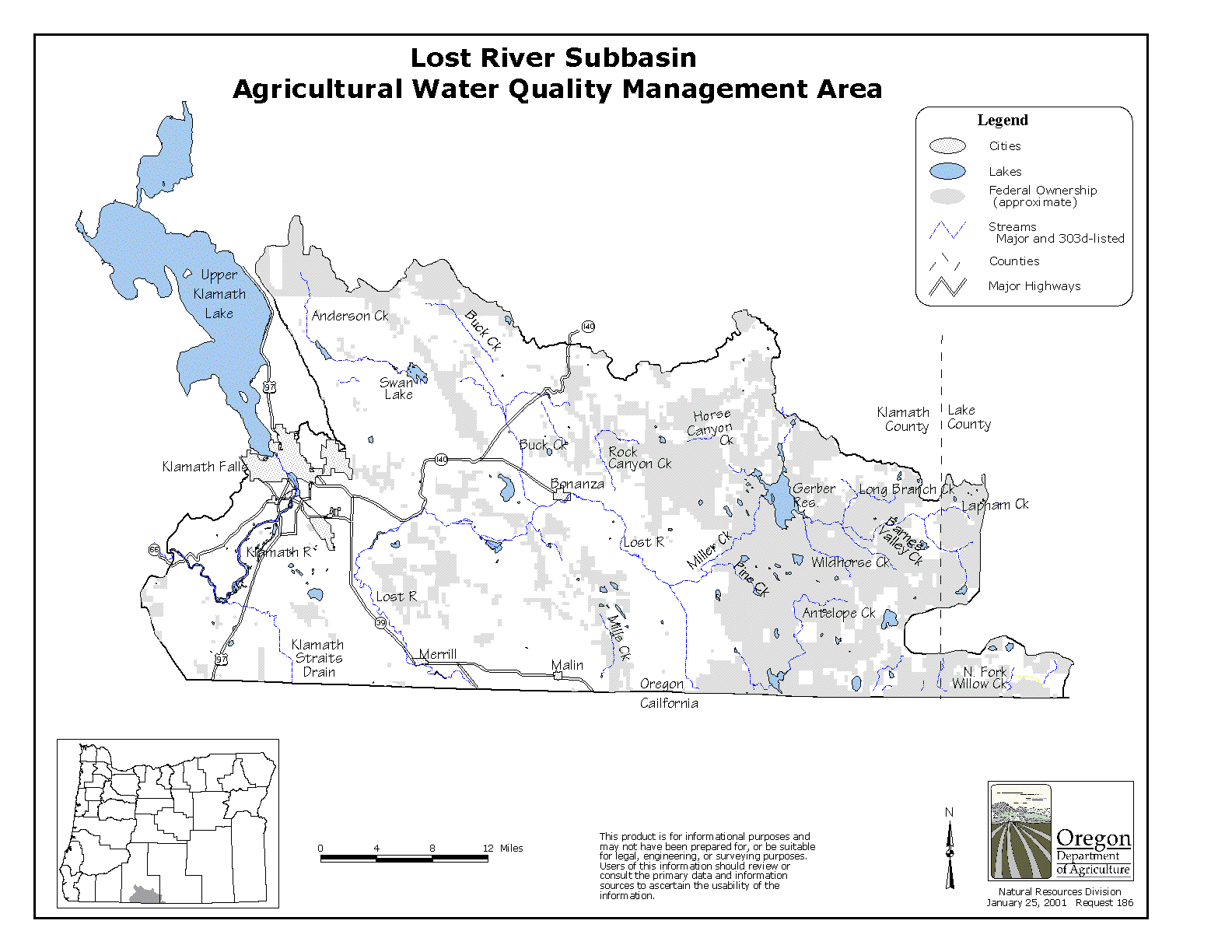
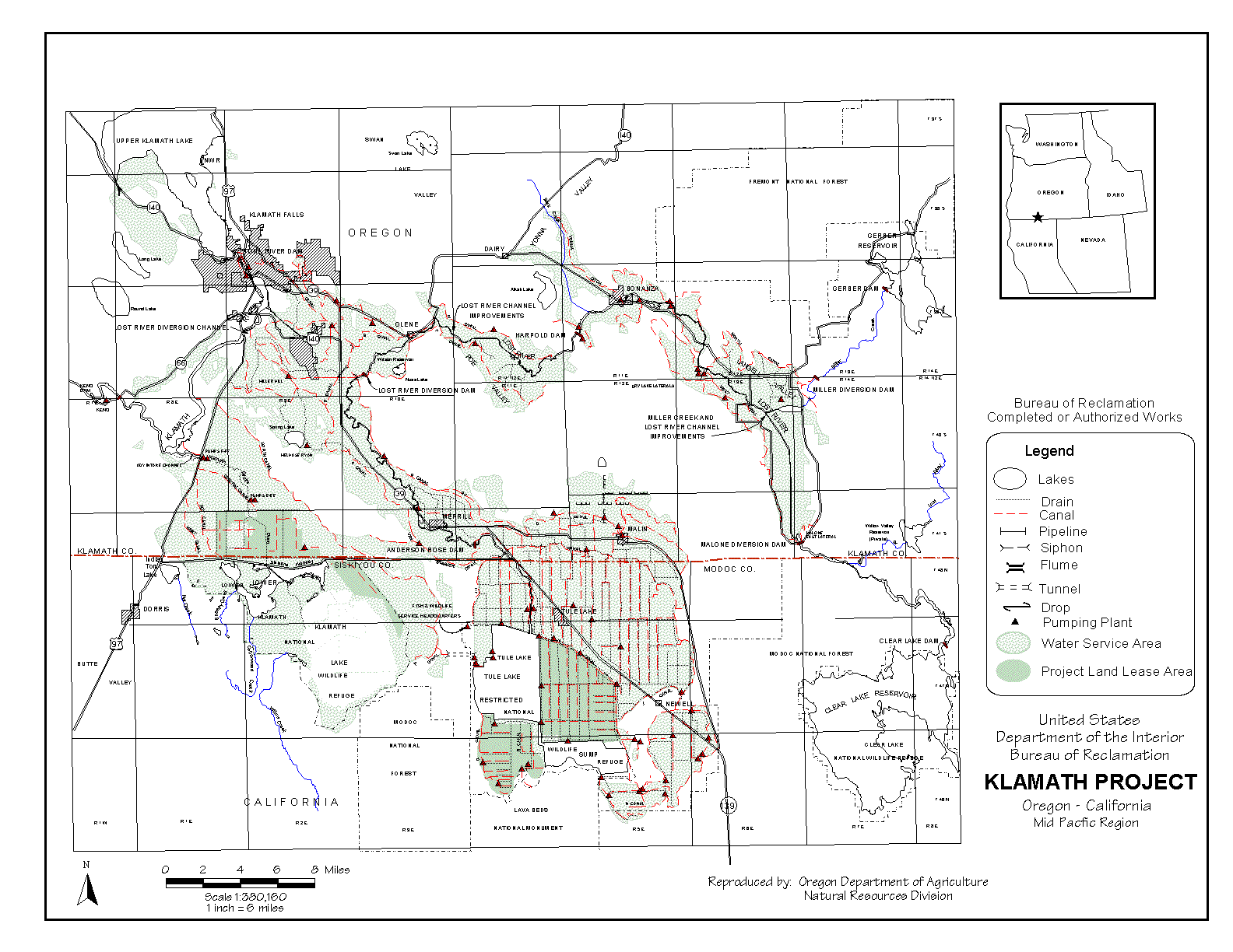
Date: September 23, 2003 To: Members of Klamath Farm Bureau and Klamath Cattlemen’s Association. You are invited to attend a joint meeting with the KFB and KCA to be held on September 30th, 2003, 6:00PM – 8:00PM, at the OSU Extension Auditorium to discuss Draft 15 of the Lost River Sub-basin Agricultural Water Quality Area Plan. The Oregon Department of Agriculture (ODA) has developed this plan with the assistance of the Lost River Land Owners Advisory Committee (LAC). It is our understanding that the ODA desires the endorsement of our LAC. After our Draft 15 is revised from your comments and suggestions, we will submit it to the Director of the ODA. The ODA will make a final draft to submit for public review and comment. Once the plan is final, there will be a review of the plan and rules every two years. Our LAC will continue to participate with the Oregon Department of Agriculture in this process. From the beginning of the plan development process we have focused on the important role that our community has in providing for our wildlife, our environment, and ourselves. We recognize the outstanding progress we have made in addressing concerns about water quality in our basin. It is our desire to create a plan that makes since and is practical. For example, we recognize that our high temperature background conditions originate largely from geothermal input into the Lost River and from the effect of ambient temperatures on the low gradient stream. We recognize that the high phosphorous background conditions originate largely from the phosphorous rich volcanic bedrock of the watershed uplands. These historical and prehistorical effects are not alterable by man’s influence. This plan is designed to encourage favorable conditions and not prohibit any practices. This plan should encourage individual landowners to create their land specific water quality management plans. At least in this watershed, we believe that a one-size fits all concept is a plan destined for failure. Individual plans make sense and will help us enhance our watershed in a relatively short period of time. One stumbling block that we have not been able to resolve with the Oregon Department of Agriculture (ODA) is in regards to legal language of reference to ORS 468. B. The ODA may try to insert this language in the final plan. The Oregon Attorney General has stated that ORS 468 B confers no authority to regulate agricultural practices to the Oregon Department of Environmental Quality (ODEQ) or to any other state agency. We believe that the inclusion of ORS 468 B language in our plan will result in a questionable expansion of ODA authority. We believe that its inclusion will result in the full scope of ODEQ regulatory authority authorized under ORS 468 B to be directly applied to regulation of agricultural practices by ODA. Much of the language in ORS 468 B is simply inappropriate for application to agriculture. This expanded regulatory authority would be draconian and would be impossible for agricultural interests to implement. Consequently, we have struck all reference to this language in Draft 15. The LAC feels that reference to ORS 468B is not necessary to have a plan enforceable by ODA Please take time to carefully review our Draft 15. Keep in mind that this plan may affect your operation. Please direct your comments and suggestions to either chair of the LAC. Please bring your comments to our meeting or respond before. This is not the official public comment period. This is an opportunity to be involved. Glenn Barrett Fax 545-1210 William D. Kennedy Fax 884-7963 DRAFT #15 August 27, 2003 LOST RIVER SUBBASIN AGRICULTURAL WATER QUALITY MANAGEMENT AREA PLAN developed by Lost River and Klamath Soil and Water Conservation District Current Local Advisory Committee Members Glenn Barrett, Co-Chair Jim Hainline Alternate: Bill Kennedy, Co- Chair Andy Hamilton Louis Randall Deb Crisp Luther Horsley Arjen deHoop Tracey Liskey Bob Gasser Bill Rust Table of Contents ACRONYMS, ABBREVIATIONS & DEFINITIONS * FOREWORD * APPLICABILITY * MAP 1 - Lost River Subbasin Agricultural Water Quality Management Area * MAP 2 - Klamath Project * 1. INTRODUCTION * 2. MISSION, GOALS, AND OBJECTIVES * 3. BACKGROUND * GEOGRAPHIC AREA AND PHYSICAL SETTING * HISTORICAL PERSPECTIVE * 4. WATER QUALITY CONCERNS * BENEFICIAL USES * WATER QUALITY STANDARDS * WATER QUALITY PARAMETERS OF CONCERN * CONTRIBUTORS TO WATER QUALITY * 5. STRATEGIES FOR ACHIEVING MISSION, GOALS, AND OBJECTIVES * A. VOLUNTARY APPROACH * B. REGULATORY MEASURES * C. AREA RULES * 6. MONITORING AND EVALUATION * EXISTING WATER QUALITY * EXISTING LAND CONDITIONS * AREA PLAN IMPLEMENTATION & PROGRESS * 7. ROLES AND RESPONSIBILITIES * CITED SOURCES * ATTACHMENT: INTERVIEWS WITH LOCAL RESIDENTS * Blank ACRONYMS, ABBREVIATIONS & DEFINITIONS ac-ft = acre-feet Area Plan - Lost River Subbasin Agricultural Water Quality Management Area Plan Area Rules - Oregon Administrative Rules 603-095-##00 through 603-095-##60 cfs - cubic feet per second BLM – Bureau of Land Management DEQ - Oregon Dept. of Environmental Quality LAC - Lost River Local Advisory Committee Management Area - Lost River Subbasin Agricultural Water Quality Management Area NWR - National Wildlife Refuge NRCS - USDA Natural Resources Conservation Service OAR - Oregon Administrative Rules ODA - Oregon Dept. of Agriculture ODFW – Oregon Dept. of Fish and Wildlife ORS - Oregon Revised Statutes OSU - Oregon State University SWCD - Soil and Water Conservation District TMDL - Total Maximum Daily Load USDA – United States Department of Agriculture "Pasture" as used in this Area Plan means land for grazing livestock; supplemental forage may be provided. This Agricultural Water Quality Management Area Plan (Area Plan) provides guidance for addressing agricultural water quality issues in the Lost River Subbasin Agricultural Water Quality Management Area (Management Area). The purpose of this Area Plan is to identify strategies to enhance water quality from agricultural lands. The provisions of this Area Plan do not establish legal requirements or prohibitions. The Oregon Department of Agriculture (ODA) will exercise its enforcement authority for the prevention and control of water pollution from agricultural activities under Oregon Administrative Rules (OARS) for the Lost River Subbasin Management Area (603-095-##00 through 603-095-##60) and state-wide enforcement procedures provided in OARS 603-090-0060 through 603-090-0120. This Area Plan applies to agricultural activities on all agricultural, rural, and forest lands within the Lost River Subbasin Agricultural Water Quality Management Area that are not owned by the federal government and are not held in Tribal Trust. The Area Plan also applies to agricultural lands in current use, those lying idle or on which management has been deferred, and lands (like private roads) not strictly in agricultural use but that support agricultural activities. This Area Plan does not address conditions resulting from Federal activities or activities governed by the Forest Practices Act. Pesticide use is governed by the Pesticide Control Act (ORS 634); those laws are administered by the ODA Pesticides Division. While the Lost River flows between two states (Oregon and California), this Area Plan addresses only agricultural lands in Oregon. The adoption of this Area Plan by other Designated Management Agencies (e.g. Tribal governments, municipalities, and federal agencies) is encouraged. MAP 1 - Lost River Subbasin Agricultural Water Quality Management Area
This Lost River Subbasin Agricultural Water Quality Management Area Plan (Area Plan) addresses bacteria, nutrient, and temperature concerns related to agricultural activities on lands in the Management Area that are neither Federal nor held in Tribal Trust. This Area Plan does not address conditions resulting from activities of Federal agencies, such as streambank erosion along the Lost River caused by water fluctuations from Bureau of Reclamation dam operations. In November 1995, the Klamath TMDL Advisory Committee was empaneled to help Oregon’s Department of Environmental Quality (DEQ) develop Total Maximum Daily Loads (TMDLs) for the Lost River Subbasin. The Committee included members from the agricultural community. The State mandated that an Area Plan be developed to address agriculture’s contributions to bacteria, nutrients, and temperature concerns. The Oregon Agricultural Water Quality Act, passed as Senate Bill 1010 in 1993 (ORS 568.900-568.933), and Oregon Administrative Rules (OAR 603-090) outline the process for the development and implementation of Agricultural Water Quality Management Area Plans to prevent and control water pollution resulting from agricultural activities. The process includes the formation of a Local Advisory Committee that consists primarily of landowners in the affected area to assist the Oregon Department of Agriculture (ODA) in the development of the Area Plan and Rules. In February 1998, the Lost River Local Advisory Committee (LAC) was convened by ODA. They are assisted by the Klamath Soil and Water Conservation District (SWCD). Members were recommended by the Klamath SWCD, agriculturalists, and local agencies. Proposed members were appointed by the Director of ODA after consultation with the Board of Agriculture. LAC members represent the interests of local landowners, producer groups, irrigation districts, fish biologists, rural communities and businesses, and the Klamath SWCD.
The LAC has a technical committee comprised of Ken Rykbost (OSU Klamath Experiment Station), Ron Hathaway (OSU-Klamath County Cooperative Extension Service), Steve Kirk (Oregon Department of Environmental Quality), and Klamath SWCD staff. Addition technical support was supplied by: Natural Resources Conservation Service (NRCS), ODA, Oregon Department of Fish and Wildlife (ODFW), US Bureau of Reclamation, Bureau of Land Management (BLM), US Fish and Wildlife Service, and others. The intent of this Area Plan is to protect water quality in the Lost River Subbasin Water Quality Management Area through voluntary activities by landowners, while sustaining the agricultural economy. ODA will use regulatory measures as a last resort when voluntary approaches do not adequately protect water quality. This Area Plan will address conditions affecting water quality that result from agricultural management of streamsides, uplands, livestock, and croplands. To the greatest degree possible, prevention and control of agricultural pollution will be encouraged in a cooperative spirit through the voluntary efforts of landowners, aided by information and technical and financial assistance from local, state, and federal agencies, and others. An Agricultural Water Quality Management Area Plan is being developed by a separate Local Advisory Committee for the Klamath Headwaters, and it primarily addresses the tributaries that flow into Upper Klamath Lake. Both Area Plans need to be examined for an area-wide view of agricultural planning for water quality in the Klamath Basin in Oregon. California does not have a similar process in place for dealing with water quality issues related to agriculture. 2. MISSION, GOALS, AND OBJECTIVES MISSION Protect water quality in the Lost River Subbasin Agricultural Water Quality Management Area, while sustaining the agricultural economy. Guiding Principles • Rely on scientifically-credible data and techniques • Emphasize maintenance, restoration, education, and monitoring • Use common sense to develop cost-effective, practical, flexible, and realistic solutions • Maintain a non-threatening, positive atmosphere • Recognize natural background water quality, including geothermal input • Recognize that proper agricultural practices improve water quality • Recognize that economic viability of agriculture is necessary to achieve improvements GOAL Prevent or control water pollution from agricultural activities to protect beneficial uses in the Lost River Subbasin Agricultural Water Quality Management Area. This Area Plan will focus on: • Bacteria • Nutrients • Temperature Several river segments in the Lost River Subbasin are identified by Oregon’s Department of Environmental Quality on its 2002 303(d) list as water-quality limited for bacteria, dissolved oxygen, pH, chlorophyll a, ammonia toxicity, and temperature. Reductions in nutrient levels are expected to alleviate the concerns related to low dissolved oxygen, high pH, chlorophyll a, and ammonia toxicity. OBJECTIVES 1. Maximize the beneficial effects of agricultural irrigation and grazing practices on bacteria loads, nutrients, and water temperature, while acknowledging that background water quality is limited due to hot springs, channelization, and the volcanic origin of soils. 2. Increase public awareness of water quality concerns beyond the realm of this Area Plan or the responsibility of the private landowner, including: • natural background conditions (geothermal springs, nutrients, algae) • fluctuation of flow in the Lost River (Bureau of Reclamation) • commingled waters (Lost River and Klamath River) • interstate waters (Oregon and California) • high water temperatures correlated with solar radiation and high ambient temperature • lack of streambank shade on wide channelized streams and impoundments • unusual weather* • urban and suburban runoff GEOGRAPHIC AREA AND PHYSICAL SETTING Location The Management Area is located in extreme southcentral Oregon, near Klamath Falls (see Map 1). The Management Area consists of the Oregon portion of the Lost River subbasin, as defined by the US Geological Survey. Its 1,313 square miles (840,320 acres) include the land draining into the Klamath River between Link River and Keno dams, Swan Lake Valley, and the Oregon portion of the Lost River drainage1. Another 1,685 square miles (107,8380 acres) of the Lost River Subbasin are in California and are outside the jurisdiction of this Area Plan. The Management Area is in Klamath County except for a small area in Lake County. Principal cities include: Merrill, Malin, Bonanza, and most of Klamath Falls. Elevation above sea level ranges from 4,050 to 6,300 feet, and averages around 4,200 feet. The Management Area includes about one-half of the lands that rely on the US Bureau of Reclamation Klamath Project for irrigation (see Map 2). Principal water bodies include: • Klamath River from Link River Dam downstream to Keno Dam, including Lake Ewauna • Oregon portions of the Lost River and its tributaries • Swan Lake Valley, a naturally closed subbasin northeast of Klamath Falls. Floodwaters from the Pine Flats area near Dairy are pumped to the Lost River in the winter. More detailed maps are available from the US Geological Survey (http:\\www.usgs.gov) and other sources. Climate Temperatures at Klamath Falls average 29ºF in winter and 67ºF in the summer2. Average winter minima throughout the Management Area are11-20ºF, and average summer maxima are 68-72ºF3. Monthly rainfall peaks in December, with a secondary peak in May just prior to the dry summers1,4. Average annual precipitation is 14 inches2, with a low of 10-12" near Malin and Merrill and a high of 18-20" near Gerber Reservoir3. Lake evaporation in the area is 36 to 42" annually, of which 80% occurs from May through October4. The growing season varies considerably from year to year, but averages approximately 120 days from about May 15 to September 152. Geology and Soils The Management Area lies in the Klamath Ecological Province and is typified by large basins consisting of lakebeds surrounded by extensive ancient lake terraces interspersed with basaltic mountains3. Many soils in the Klamath Province are related to ancient sedimentary and tuffaceous lakeshore terraces and basins3. These soils generally have loamy surface layers and loamy to clayey subsoils. The surface is often stony or gravelly, and hardpans may be present. These features are important to irrigated cropland agriculture on sloping lands. Many rangelands are typified by basalt stones and outcrops on the surface, especially on upland slopes and plateaus. Associated soils commonly are shallow over clayey subsoils. These soils readily erode if herbaceous cover is depleted. Stones, exposed by erosion, can form a stone pavement that seriously impedes reestablishment of forage plants. Bottomlands, low terraces, and floodplains are dominated by moderately deep or very deep, moderately well-drained to very poorly drained soils4. These soils have slopes of 0-2%, are sometimes subject to flooding, and all have a high water table. Benches, terraces, and low hills are dominated by shallow to very deep, excessively-drained and well-drained soils. Slopes range from 0-35%, and land is mostly used for irrigated crops. Mountainous areas are dominated by shallow to very deep, well-drained soils derived from tuff and basalt. Rock outcrops are common. Slopes range from 1-60%, and land generally is used for timber, range, and wildlife habitat. High concentrations of phosphorus may enter Management Area streams via two natural soil pathways. Soils naturally high in phosphorus have been documented in the Wood River Valley upstream of the Management Area5. In the Management Area, mapping by the Oregon Dept. of Geology has shown a high percentage of basaltic andesites as the surface rocks in and near Langell Valley6. These basaltic andesites have higher P205 percentages (0.52-0.84) than are typical in most volcanic terrains. Hydrology The Management Area consists of a modified hydrologic system. A large US Bureau of Reclamation agricultural project known as the Klamath Project reconstructed the hydrology of this basin through a complex system of pumps and canals. The water from the Lost River is reused many times by the different users, mainly agriculture and wildlife refuges. The Lost River begins with California tributaries to Clear Lake, a large shallow reservoir1. Upon leaving Clear Lake, the Lost River enters Oregon and flows through Langell Valley. Miller Creek flows into the Lost River in Langell Valley; Miller Creek’s flows are regulated at Gerber Reservoir. Near Bonanza, the river turns west; large springs in this area contribute substantial inflow (over 35,000 ac-ft per season) to the shallow, sluggish stream with a gradient of < 0.1 ft/mile7. Upon flowing through Olene Gap, 10 miles east of Klamath Falls, the river turns southeast and flows along the base of Stukel Mountain. It reenters California near Merrill, Oregon and flows through a series of canals to provide irrigation water to the Tulelake area2. It floods and is retained in two National Wildlife Refuges (Tule and Lower Klamath Lakes) before reentering Oregon and flowing to the Klamath River via Straits Drain. The Lost River historically ended in Tule Lake in California and did not flow to the Klamath River; Tule Lake and Lower Klamath Lake were not connected8. The Klamath Project connected Tule and Lower Klamath Lakes via a tunnel through Sheepy Ridge through which water is now pumped. Groundwater resources are not well understood in the Klamath area. The US Geological Survey and the Oregon Water Resources Department are cooperating in the Upper Klamath Basin Groundwater Study (http://oregon.usgs.gov/projs_dir/or180/). This study will characterize and quantify the groundwater system in 8000 square miles of California and Oregon. The results will help agencies and water users evaluate potential effects of new development on existing groundwater users and help identify areas where additional groundwater development can occur without adversely affecting streamflow. Historical Tule Lake was a large natural sump with no surface outlet, which at times had a surface covering 90,000 acres1. During periods of high runoff, flows from Lost River would raise Tule Lake to its highest elevation. The lake would then slowly recede during the summer and fall due to evaporation. Lower Klamath Lake received its waters when the Klamath River naturally backed up around Keno during high spring flows, raising the water level enough for the Klamath water to flow up Straits Drain, where it was stored in Lower Klamath Lake9. Klamath Project The Klamath Project, located on the Oregon-California border, was one of the earliest Federal reclamation projects1,2,9. In early 1905, Oregon and California State Legislatures ceded title ("Cession Acts") in Lower Klamath and Tule Lakes to the United States for project development under provisions of the Reclamation Act of 1902. Construction was authorized by the Secretary of the Interior on May 15, 1905 for project works to drain and reclaim lakebed lands of the Lower Klamath and Tule Lakes; to store waters of the Klamath and Lost Rivers; to divert irrigation supplies; and to control flooding of the reclaimed lands. As Tule Lake receded, reclaimed lands were leased by the government for farming until opened to homesteading. To protect developed homestead lands from flooding, areas at lower elevations were designated as sump areas and reserved for flood control and drainage. Some of the marginal sump acreage subject to less frequent flooding was made available for leasing, but retained in Federal ownership. The ceded lands were offered by the United States to homesteaders from 1917-1948. Project construction costs were repaid to the US Government. The flood control sumps and the remaining leased lands are now part of Tule Lake National Wildlife Refuge in California and the Lower Klamath National Wildlife Refuge. The Bureau of Reclamation manages the Lost River primarily for irrigation and flood control2. The Klamath Project irrigates 123,767 acres in Oregon, almost all of which are in the Management Area4. Two main sources supply water for the Klamath Project. The natural source consists of the Lost River. The Lost River is controlled by various dams in Oregon. The other source consists of Upper Klamath Lake and the Klamath River, which are introduced artificially into the Lost River through the Lost River Diversion Canal. Water can flow both ways in the nearly eight-mile long canal, allowing excess water from Lost River to flow to the Klamath River during periods of high flow and providing water from Klamath River to Lost River when irrigation demand is high. The A-Canal diverts water from Upper Klamath Lake a short distance above Link River Dam. This allows Klamath Lake water to enter the Lost River at several locations, the furthest upstream being approximately two miles below Harpold Dam. Upstream of that point, irrigation water is supplied exclusively by Clear Lake and Gerber Reservoir. Malone Dam and the Miller Creek Diversion Dam (below Gerber Reservoir) divert water into peripheral canals that irrigate approximately 18,000 acres of pasture and cropland. Langell Valley, historically a complex of wetlands, was drained via the Lost River Improvement Channel in 1949. The channelized portion of the Lost River below Malone Reservoir functions as drainage, flood control, and water delivery to the Langell Valley Irrigation District river pumps and the Horsefly Irrigation District pumping plants near Bonanza. Between 1951 and 1967, Project lands in the Management Area received about 368,000 ac-ft per year1. Roughly 266,000 ac-ft (73% of the total Klamath Project water supply) were imported annually from Upper Klamath Lake and the Klamath River, primarily through the A-Canal. The amount of water diverted varies every year, depending on seasonal flows and rainfall, and is a small percentage of the average 1,154,000 ac-ft of Klamath River water that annually flows over the Link River dam10. About 20,000 ac-ft are diverted annually from the Klamath River via the Lost River Diversion Canal. Clear Lake, Gerber Reservoir, and Bonanza-Big Springs each contribute 35,000-38,000 ac-ft annually to the Project1. The average annual efficiency across the Klamath Project is 92%11. An effective sophisticated seasonal pattern of water use has evolved in the Klamath Project. Early in the irrigation season water is distributed to meet immediate irrigation requirements and to replenish soil moisture throughout the Project area. The stored soil moisture allows the project to meet peak consumptive use demands even when these demands exceed the projects’ capacity to divert and deliver surface water. Tailwater is reused multiple times and therefore is vital for maintaining the high irrigation efficiency. Klamath Basin lakes evaporate 3.5 ac-ft of water annually12. This is greater than the 2.5 ac-ft consumed by Klamath Project crops. The Klamath Drainage District serves over 27,000 acres that drain into the Straits Drain13. An average of 2.27 ac-ft per acre is diverted annually from the Klamath River. Some water is reused within the District with the assistance of tailwater recovery pumps, and an average of 43,430 ac-ft is returned to the Straits Drain annually. Historical summer streamflows on the Klamath River at Link River Dam range from 200-1100 cfs4. In addition, two power plants along the Link River have ‘power claims’ established prior to 1905 that amount to 355 cfs1. Mean annual streamflow of the Lost River at Malone Diversion Dam is 33,960 acre feet, and 174,830 acre feet at Harpold Reservoir4. Geothermal Activity Geothermal waters heat homes and buildings, including the Oregon Institute of Technology1. Geothermal wells on the east flank of the Klamath Hills are used to heat greenhouses and raise tropical fish14. Many hot springs are located in the river and in aquifers near the river15. Hundreds of warmwater wells are present with temperatures ranging from 68ºF to 104ºF. Some springs with temperatures exceeding 140ºF are found near Olene Gap, the northeastern part of Klamath Falls, and the southwest flank of the Klamath Hills15; temperatures of 199ºF have been recorded on the east flank of the Klamath Hills14. The hot waters are located near, and are presumably related to, major geologic fault and fracture zones. Additional undeveloped geothermal resources are known to exist in the region; numerous studies have been conducted and reports are available. The LAC associates geothermal activity with elevated background water temperatures in the Management Area.
Land Use The Management Area is characterized by rural lands. Over 60% (509,000 acres) is privately owned11. The rest is managed primarily by the US Fish and Wildlife Service, Bureau of Land Management, and the US Forest Service. Limited forests exist in the Management Area, with most of the woodlands consisting of juniper stands4. These areas are used primarily for range and wildlife habitat. Western junipers have expanded rapidly onto noncultivated and nonforested areas3. Junipers are known for high water consumption and aggressive competition for forage species12,18. This can increase soil erosion and contribute nutrients, including phosphorus, to streams14. Heavy infestations undoubtedly diminish water recharge to streams and groundwater. Agriculture is a significant land use in Klamath County. Klamath County’s gross agricultural income approximated $110,000,000 in 1998 (preliminary data)19. Crops accounted for approximately $55,000,000, one-half of which came from hay and forage. Livestock, including primarily beef cattle, horses, and $13 million from dairies, contribute the rest. With an economic multiplier of 2.0, each dollar of agricultural income in the county generated $2 of economic activity locally, thus contributing over $220,000,000 in 1998. The Management Area includes a significant portion of the crop production in Klamath County. Crops include alfalfa, potatoes, sugar beets, garlic, onions, strawberry plantlets, mint, field peas, small grains, pasture, and range lands (primarily used for cattle production). The Management Area also includes Klamath County’s dairies. The irrigation season extends year-round, but is predominantly March through October2. The first water rights for irrigation were claimed in 1870, for lands in Swan Lake Valley and in Langell Valley along the Lost River4. Water rights have been adjudicated for Langell Valley and much of Poe Valley, whose water comes solely from Gerber Reservoir and Clear Lake, but water rights associated with Klamath River water currently are being adjudicated. Approximately 70,000 acres of agricultural lands upstream of the Management Area (in the Upper Klamath Lake watershed) have been converted to wetlands or short-term water storage sites. The US Fish and Wildlife Service manages a system of National Wildlife Refuges (NWRs) in the Klamath Basin primarily for waterfowl habitat; the wide and shallow lakes are important stops for migratory waterfowl on the Pacific Flyway. Bear Valley NWR and about 7,000 acres of Lower Klamath NWR are in the Management Area. Bear Valley NWR drains into Lower Klamath NWR. Clear Lake NWR is in California at the headwaters of the Lost River. Upper Klamath and Klamath Marsh NWRs are upstream of the Management Area via the Klamath River. Most of Lower Klamath NWR (43,000 acres) and all of Tule Lake NWR (37,000 acres) are in California; the Lost River floods and flows through them and exits into Oregon via Straits Drain. Three of these Klamath Basin refuges (Clear Lake, Tule Lake, and Lower Klamath) are within the Klamath Project, and the Bureau of Reclamation manages some of these waters for flood control and irrigation while the Fish and Wildlife Service manages for fish and wildlife. All of these areas, whether in the Management Area or not, contribute to water quality concerns in the Management Area.
Sources: Interviews with Barney Hoyt, Mary Taylor, Ann Fairclo, George Stevenson, Taylor High, Van Landrum (1924-2002), Alvin Cheyne, Walter Smith, Ron McVay, Tag Howland, Louis Randall, Earl Miller, Marilyn Livingston, and Margaret Cheyne. 1999-2000. Of the people interviewed, the earliest memories go back to 1925 with many families homesteading the area as early as 1885. It was unanimous amongst all interviewees that the water in the Lost River was always "green" with algae. Most people could remember swimming in the river at some point in their childhood, but had to bathe immediately afterward to remove the algae. Several species of fish were remembered, suckers, catfish, chubs, sunfish, perch and occasionally a trout or bass was caught. Many people stated that during the early part of the 1900’s it was very unusual to see a deer. There is a story (recorded by Peter Skene Ogden) of 50 experienced hunters nearly starving to death in the Klamath Basin on one of their expeditions. They reportedly had to eat their horses to stay alive and said it had not been worth the effort it took to get here. Most people interviewed remembered a wide variety of animals: beaver, otter, muskrat, quail, pheasant, deer, coyotes, cougars, bobcats, and antelope. There are documented claims of six cougars killed in one day. Wolves were present and believed to have been a factor in the lack of game. It was said repeatedly that the Lost River flooded nearly every year, and would be intermittent some years during the summer months until the Wilson Reservoir Dam was built in 1911. Crops were more limited than today. The primary crops grown were grain, hay (mostly meadow), pasture, potatoes, and dry land rye20. John Applegate, an early explorer, stated in one of his reports that potatoes were grown commercially prior to 1900. There were cattle and sheep (several thousand sheep at one time) and most people had several milk cows. There are many hot springs in the Lost River and surrounding area. People used to scald hogs at Olene Gap. The water was believed to have been around 150 degrees. Bathhouses were located throughout the Lost River subbasin on the hot springs. Walt Smith heats his home from one of the hot springs near the river and it is 145 degrees. The hot spring at the old bath house near Cheese Factory Rd is 150 degrees. Water from Klamath Lake enters the Management Area via the Klamath River. The water quality of Klamath Lake was always bad. Applegate reported having to travel during the cool part of the day and having to wear masks or scarves to help eliminate the odor. In 1855, Abbot journeyed to Cove Point; his journal stated that the water was brown and bitter, and animals would not drink it. Fremont reported that the water in Klamath Lake at Rattlesnake Point was too putrid to water horses. The Federal Clean Water Act requires that each state designate the beneficial uses of water, select water quality parameters most directly related to the beneficial uses, and set standards for those parameters. DEQ convened the Klamath TMDL Advisory Committee in November 1995 to develop a plan to improve water quality in the Management Area: the DRAFT Citizen’s Guide to Improving Water Quality in the Klamath River, Lake Ewauna, Lost River, and Tributary Streams to the Lost River. This DRAFT was never approved by the TMDL Advisory Committee. Their work is currently on hold. The TMDL for the Upper Klamath Lake area was approved by EPA in 2002 and is currently under review. Eventually the Lost River TMDL Committee will resume their task, and an Area Plan will become a part of the TMDL package for the Lost River Subbasin by addressing the load allocated to agriculture.
As described by DEQ, beneficial uses for the Management Area include domestic water, irrigation, livestock watering, fisheries, recreation, and aesthetics.
DEQ sets water quality standards in Oregon. Certain standards are selected for review every three years by DEQ.
WATER QUALITY PARAMETERS OF CONCERN Rivers and streams in the Management Area that violate Oregon’s current water quality standards are listed in Table 221.
The supporting data were collected by Bureau of Land Management, US Forest Service, Bureau of Reclamation, US Geologic Survey, and DEQ. Due to limited data, water quality issues can only be generalized: • Water quality at low elevation sites of the Lost River is generally worse than water quality at high elevation sites. • Water quality in the Lost River deteriorates within the NWRs. The NWRs are located on a reach of the Lost River that flows from Oregon into California and then back to Oregon. This California reach of the river is outside the jurisdiction of this Area Plan. • The amount of dissolved oxygen in the Klamath River decreases as the river moves downstream from Link River to Keno Dams (Map 2). Dissolved oxygen levels are very low at times during the summer. Possible sources include decaying wood chips on the river bottom and the slow, meandering nature of the river. At times, dissolved oxygen in the Straights Drain is higher than in the Klamath River where it enters. Low dissolved oxygen, high pH, ammonia toxicity, and excessive chlorophyll a generally result from excessive plant growth, which is stimulated by high nutrient concentrations in the water. Higher temperatures also stimulate plant growth. These parameters are related to fish habitat. DEQ has made it clear that more data are needed to accurately determine the locations, extent, and sources of specific water quality issues22. A primary source of pollution in the Management Area is poor water quality from Upper Klamath Lake, which enters the: Klamath River at Link River Dam; Klamath Project at A, North, and ADY Canals; and Lost River through the Lost River Diversion Canal. Pollutants from point sources (industrial and municipal discharges) and non-point sources (agriculture, urban runoff, refuge activities) worsen these background conditions. Pinpointing the numeric contributions from nonpoint sources is difficult due to the complex hydrological system. The LAC recognizes that water quality from Upper Klamath Lake, river operations by the Bureau of Reclamation, wildlife refuges, urban areas, irrigation districts, and activities in California affect water quality. These issues are outside the responsibilities and control of private landowners in the Management Area. 5. STRATEGIES FOR ACHIEVING MISSION, GOALS, AND OBJECTIVES To achieve clean water an effective strategy must reduce transport of pollutants to surface water and infiltration of pollutants into ground water. The primary strategies to minimize pollution from agricultural and rural lands lie in reducing erosion, pollutants in runoff, and infiltration of pollutants to groundwater. Pollution will be minimized through a combination of landowner education, land treatment, and implementation of appropriate management practices. Voluntary efforts will be the primary means to prevent and control agricultural sources of pollution. However, regulatory measures are included as an implementation strategy. ODA will pursue enforcement to gain compliance with Area Rules only when reasonable attempts at a voluntary solution have failed. (See below.) Prevention and control of agricultural pollution will be encouraged in a cooperative spirit through the voluntary efforts of landowners, aided by information and technical and financial assistance from watershed councils, local, state, and federal agencies, and others. The Klamath and Lakeview SWCDs will be the main local support agencies. Education plays a critical role in the success of this Area Plan. The NRCS and SWCDs will work together to provide farmers and ranchers in the Management Area with information about the goals and objectives of the Area Plan and requirements of the Area Rules. Landowners have flexibility in choosing management approaches and practices to address water quality issues on their lands. (Area Rules cannot prohibit specific practices.) Landowners may choose to develop management systems to address problems on their own, or they may choose to develop a voluntary conservation plan to address applicable resource issues. Landowners may seek planning assistance from their SWCD, NRCS, any other agency, or a consultant.
The following strategies will be employed by the appropriate SWCD in cooperation with the landowner. 1. Plan and implement technically sound and economically feasible conservation practices that contribute to meeting Area Plan objectives. a. Develop voluntary conservation plans with planning and implementation assistance. b. Promote incentive and cost-share programs to assist implementation of plans and related practices, by annually identifying water quality funding needs with agencies that provide cost-share and technical assistance to agricultural operators. 2. Create a high level of awareness and an understanding of water quality issues among the agricultural community and rural public, in a manner that minimizes conflict and encourages cooperative efforts. a. Incorporate Area Plan implementation as a priority element in the SWCDs’ Annual Work Plans and Long Range Plans, with support from partner organizations. b. Promote and conduct cooperative, on-the-ground projects with partner organizations to solve critical problems identified by landowners and land managers. c. Showcase successful practices and systems and conduct annual tours for landowners and media. d. Recognize successful projects and practices through appropriate media and newsletters. e. Conduct educational programs to promote public awareness of water quality issues and their solutions. f. Proactively offer and provide site evaluations on any lands within the Management Area to assess conditions that may affect water quality. g. Prioritize subwatersheds within the Management Area for targeting implementation and improvement strategies. 3. Encourage adequate funding and administration of the program to achieve Area Plan goals and objectives by systematic, long-range planning and focusing of coordinated efforts on full-scale, watershed-based approaches; identifying needs; developing projects; actively seeking funding; and ensuring successful implementation of funded projects. In addition to the voluntary strategies, Area Rules are included as an implementation strategy. Area Rules are developed and adopted to achieve water quality standards and to prevent and control water pollution. Area Rules that describe conditions on the land are based on a scientific relationship between the land condition and specific water quality problems. For example, Area Rule (5)(a) addresses those characteristics of riparian areas that provide water temperature moderation and filtration of potential pollutants. Land condition-based Area Rules provide landowners a straightforward way to determine if their management is protective of water quality. Landowners are not required to monitor water quality to determine compliance with land condition-based Area Rules. Landowners that are in compliance with the Area Rules will not be held responsible for water quality conditions that the rule was designed to protect. ODA will use enforcement where appropriate and necessary to gain compliance with the Area Rules. Any enforcement action will be pursued only when reasonable attempts at a voluntary solution have failed. The following Area Rules provide for resolution of complaints. Complaints and Investigations (OAR 603-095-##60) (1) When the department receives notice of an alleged occurrence of agricultural pollution through a written complaint, its own observation, through notification by another agency, or by other means, the department may conduct an investigation. The department may, at its discretion, coordinate inspection activities with the appropriate Local Management Agency. (2) Each notice of an alleged occurrence of agricultural pollution will be evaluated in accordance with the criteria in ORS 568.900 to 568.933 or any rules adopted thereunder to determine whether an investigation is warranted. (3) Any person allegedly being damaged or otherwise adversely affected by agricultural pollution or alleging any violation of ORS 568.900 to 568.933 or any rules adopted thereunder may file a complaint with the department. (4) The department will evaluate or investigate a complaint filed by a person under section OAR 603-095-##60(3) if the complaint is in writing, signed and dated by the complainant and indicates the location and description of: (a) The waters of the state allegedly being damaged or impacted; and (b) The property allegedly being managed under conditions violating criteria described in ORS 568.900 to 568.933 or any rules adopted thereunder. (5) As used in section OAR 603-095-##60(4), "person" does not include any local, state or federal agency. (6) Notwithstanding OAR 603-095-##60, the department may investigate at any time any complaint if the department determines that the violation alleged in the complaint may present an immediate threat to the public health or safety. (7) If the department determines that a violation of ORS 568.900 to 568.933 or any rules adopted thereunder has occurred, the landowner may be subject to the enforcement procedures of the department outlined in OARs 603-090-0060 through 603-090-0120.
The Area Rules are enforceable by ODA and are cited here in bold text in boxes for your information. The Area Plan is not enforceable. The Area Plan and Rules complement each other. The Area Plan provides an overall proactive strategy for meeting the Plan’s water quality objectives and for complying with the Area Rules. All landowners conducting agricultural activities in the Management Area on lands (including timber lands) that are neither Federal nor held in Tribal Trust must comply with the Area Rules (OAR 603-095-##00 through 603-095-##60). "Landowner" includes any landowner, land occupier or operator (OAR 603-095-0010(24)). The landowner’s responsibility is to implement measures that ensure compliance with these Area Rules. Sanctions can come into effect from ODA if a landowner is out of compliance with the Area Rules. ODA enforcement/compliance activities will be conducted as provided by ORS 568.900 through 568.933 and OARS 603-90 and 603-95. The appropriate SWCD will be informed by ODA of compliance actions. Activities governed by the Forest Practices Act are outside the jurisdiction of this Area Plan. Pesticide use is governed by the Pesticide Control Act (ORS 634); those laws are administered by the ODA Pesticides Division. Area Rules may change over time, as information becomes available on land conditions and water quality.
Oregon Administrative Rules 603-095-##40 Requirements (1)(a) A landowner is responsible for only those conditions resulting from activities controlled by the landowner. A landowner is not responsible for conditions resulting from activities by landowners on other lands. A landowner is not responsible for conditions that are natural, could not have been reasonably anticipated, or that result from unusual weather events or other exceptional circumstances. Landowners will not be required to implement practices or management systems that are not practical and effective for their operation. Landowners are not responsible for conditions resulting from a change in activities required by exceptional circumstances, such as severe droughts or government mandated action such as, but not limited to, water delivery curtailment or wetland restoration. ODA will consider costs, benefits, and economic feasibility when working with a landowner to resolve a compliance issue. ODA will seek input from the local SWCD prior to evaluating conditions for compliance or requiring a schedule of corrective practices. (b) Unless otherwise restricted by state or federal law, conditions resulting from limited duration activities are exempt. (2) Landowners are encouraged to seek financial and educational assistance from various sources (programs) to prevent or correct problems and conditions on their land prior to an enforcement action. Funding and educational sources include USDA Farm Services Agency, local SWCDs, watershed councils, other state and Federal programs, and private sources. (3) Definition Specific to the Management Area (a) For the purposes of these rules, Agricultural Management Unit (AMU) means a field, group of fields, or other land units of the same land use and having similar treatment needs and planned management. AMU is a grouping identified by the landowner to simplify planning activities and facilitate development of conservation management systems. An AMU has definite boundaries, such as fence, drainage, vegetation, topography or soil lines.
The following Area Rules 603-095-##40(4) through (6) establish requirements where there are agricultural management or soil-disturbing activities. Sheet, rill, and wind erosion (Parameter addressed: nutrients)Definitions: Wind erosion = the actual movement of soil by wind to such a degree that the top soil is being noticeably destroyed or conditions which will result in a noticeable movement of the topsoil by wind action. (ORS 568.810 (2)) Sheet erosion = removal of a fairly uniform layer of soil from the land surface by runoff water. (OAR 603-95-0010(15)) Rill erosion = erosion process in which numerous small channels only several inches deep are formed and which occurs mainly on recently disturbed soils. The small channels formed by rill erosion would be obliterated by normal smoothing or tillage operations. (OAR 603-95-0010(14)) "T" = maximum average annual amount of soil loss from erosion, expressed in tons per acre per year, that is allowable on a particular soil. This represents the tons of soil (related to the specific soil series) that can be lost through erosion annually without causing significant degradation of the soil or potential for crop production. T values for the Management Area are listed in the 1971 Klamath County Soil Survey. Requirement (OAR 603-095-##40): (4)(a) Combined sheet, rill, and wind erosion of soil, averaged through a crop rotation period, must be less than or equal to T, or an alternative standard declared by the NRCS Oregon State Conservationist for certain soils, for any Agricultural Management Unit after December 31, 2005. Any alternative erosion control standard must reduce the delivery of sediment to adjacent watercourses as much as is practicable. (b) If an alternative standard is needed for certain soils, ODA and the Klamath SWCD, acting as the Local Management Agency, will request an alternative recommendation from the NRCS State Conservationist for an appropriate erosion control standard. Streamside Areas (Parameters addressed: bacteria, nutrients, temperature) Requirement (OAR 603-095-##40): (5)(a) Agricultural activities within an Agricultural Management Unit boundary must not prevent the establishment or improvement of vegetation that provides bank stability and shading of natural or channelized streams, after December 31, 2005. (b) Except as provided in (a), grazing, weed control, and other common agricultural activities are allowed in riparian areas.
Greenline Riparian-Wetland Monitoring is recommended, but not required, for monitoring riparian condition23. It is a process developed by the Bureau of Land Management (BLM) to generate baseline data that describes existing conditions, and it is designed to detect changes in plant community succession. Animal Feeding Operations (Parameters addressed: bacteria, nutrients) Requirement (OAR 603-095-##40): (6)(a) Effective on rule adoption, landowners must prevent movement of stored animal waste to waters of the state. (b) Waste storage and application shall be done in such a way as to keep from exceeding beneficial use for forage and/or crops. Scientifically-sound monitoring can provide valuable information on how much effect the Area Plan is having, how extensively it is being implemented, and where more efforts are needed. The LAC expects to participate in local monitoring efforts. The LAC acknowledges that monitoring is an important, ongoing activity throughout the Management Area. Several assessments are being conducted that will help determine current water quality conditions. ODA is responsible for monitoring land conditions that influence water quality in agricultural areas. ODA will provide funding to support this activity. The LAC, ODA, and the Klamath SWCD will evaluate the effectiveness of the Area Plan in improving water quality and riparian conditions. Natural background water quality is affected by low gradient streams, hot springs, channelization, phosphorus from eroding volcanic bedrock, wetland processes, high waterfowl populations, and other local phenomena. Due to the complex nature of the system, it has been difficult to quantify natural, background water quality. Insufficient data have been collected to determine the geographic extent, magnitude, and source of water quality concerns. The LAC strongly desires to see more extensive analysis of existing data and collection of new data to more precisely determine agriculture’s contribution to water quality in this subbasin. This will help the LAC refine and improve the Area Plan in the coming years. Landowners may wish to monitor existing land conditions, such as vegetative composition of riparian areas and the soil loss due to sheet, rill, and wind erosion. For riparian vegetation, photographic records with a time sequence of photographs taken from the same point are the simplest method for qualitative assessments and for monitoring of trends. The greenline transect provides a more quantitative measurement of riparian vegetation.
AREA PLAN IMPLEMENTATION & PROGRESS ODA, in collaboration with the LAC and the Klamath SWCD, is responsible for determining progress towards Area Plan goals. The Klamath SWCD, as the Local Management Agency, will maintain a Memorandum of Agreement with ODA that outlines their responsibilities for providing and tracking educational outreach and technical assistance. The Klamath SWCD and ODA, in collaboration with the LAC, will: • formulate key questions to be answered by monitoring • participate in developing and evaluating outreach and education programs designed to increase public awareness and understanding of water quality issues • review reports and conduct demonstration projects and tours to promote successful management practices and systems • evaluate the adequacy of technical and financial assistance sources available to the agricultural community to implement alternative practices, monitoring, and education. Additional resources will be pursued where needed. Progress and success of implementation efforts will be assessed through compliance with Area Rules and State standards and the measurement of water quality improvement over time.
TOTAL MAXIMUM DAILY LOADS (TMDLs) TMDLs will not be addressed in this Area Plan until the courts determine the jurisdiction of TMDLs over nonpoint sources.
AREA PLAN DEVELOPMENT ODA is the Designated Management Agency for controlling pollution from agricultural activities on agricultural, rural, and forestry lands in the Management Area. ODA is authorized to develop and carry out a water quality management plan for any agricultural or rural lands, where a water quality management plan is required by state or federal law. The Klamath SWCD is the Local Management Agency for development of the Area Plan. They assist with meetings, administration, outreach, and providing technical assistance to landowners. The Lakeview SWCD will provide assistance to landowners in Lake County. The Director of ODA appointed the Lost River Local Advisory Committee (LAC) representing local agricultural and producer groups, irrigation districts, fish biologists, rural communities and businesses, and the Klamath SWCD to assist with the development of this Area Plan and Rules. The LAC will reconvene biennially to review Area Plan implementation and amend the Area Plan and Rules as necessary based on new knowledge and understanding of natural processes. The public is encouraged to participate in the Area Plan development process. All LAC meetings are open to the public, announced in the Klamath Herald and News, and closely follow Oregon’s Public Meeting Laws. ODA will hold a public comment period to review the draft Oregon Administrative Rules associated with this Area Plan; the comment period will include a public hearing in the Lost River area. Future amendments to the Rules will also have public comment periods. AREA PLAN IMPLEMENTATION The day-to-day implementation of this Area Plan will be accomplished through Memoranda of Agreement between the Klamath and Lakeview SWCDs and the Oregon Department of Agriculture. Under such agreements, the SWCDs will act as the Local Management Agencies. Landowners may choose to seek financial and technical assistance from private sources. Or, as resources allow, Klamath and Lakeview SWCD, NRCS, Cooperative Extension, and Klamath Experiment Station staff are available to assist landowners in evaluating effective practices for addressing soil erosion and runoff. Personnel in SWCD and NRCS offices can also design and assist with implementation of practices, and assist in identifying any sources of cost-sharing funds for the construction and/or use of some of these practices. Implementation priorities will be established on a periodic basis through annual work plans developed jointly by the SWCDs and ODA. ODA and the SWCDs will provide presentations to interested groups on an ongoing basis. They also will meet individually with landowners to explain the Area Plan and Rules and to provide site-specific educational reviews of land conditions relative to water quality. Any actions related to determination of noncompliance with the Area Rules or enforcement will be taken up directly by ODA, as outlined in OARs 603-090. Evaluation of Area Plan success will be the joint responsibility of the LAC, Klamath SWCD, and ODA. 1 2 Map and Factual Data on the Klamath Project. Map No. 12-208-124. Bureau of Reclamation. 1995.3 The Ecological Provinces of Oregon. E. William Anderson, Michael M. Borman, and William C. Krueger. Oregon Agricultural Experiment Station. May 1998.4 Soil Survey of Klamath County, Oregon: Southern Part. US Dept. of Agriculture - Natural Resources Conservation Service. April 1985.5 Nutrient loading of surface waters in the Upper Klamath Basin: agricultural and natural sources. Oregon State University Agricultural Experiment Station. Special Report 1023. March 2001.6 Preliminary geologic map of the Bryant Mountain and Langell Valley quadrangles, Klamath County, Oregon. M.D. Jenks and J.D. Beaulieu. Oregon Department of Geiology and Mineral Industries. In prep.7 Data from the Natural Resources Conservation Service. Presented by the Klamath SWCD to the LAC.8 Bureau of Reclamation. Personal communication.9 Use and Development of Irrigation Water in the Klamath Basin. Klamath Basin Water Users. 1995.10 Water Resources Data-Oregon-Water Year 1993. US Geological Survey. Water - Data Report OR-93-1. 1994.11 Klamath Project Historical Water Use Analysis: Klamath County, Oregon and Siskiyou County, California. Developed for the US Department of Interior Bureau of Reclamation. Davids Engineering, Inc., Davis, California. 1998.12 Letter from Marshall Staunton to Doug Tedrick (Bureau of Indian Affairs). Dated January 20, 2002.13 Klamath Drainage District data, supplied by Luther Horsley.14 Lost River Local Advisory Committee members.15 Hydrogeologic Appraisal of the Klamath Falls Geothermal Area, Oregon. Geohydrology of Geothermal Systems. Edward A. Sammel. Date unknown.16 Mike Limb. Bureau of Land Management - Geographic Information Systems. Klamath Falls. Personal communication.17 Some ecological attributes of western juniper. Eddleman, L. Special Report. Oregon State University Agricultural Experiment Station. Corvallis, OR. Pages 32-34. 1983. 18 Historic expansion of Juniperus occidentalis (western juniper) in southeastern Oregon. Miller, R.F. and J.A. Rose. Great Basin Naturalist 55:37-45. 1994. 19 Extension Economic Information Office. Oregon State University. Corvallis. 1999.20 A Status Report on Water Resources Development in the Upper Lost River Watershed. Upper Lost River Division Klamath Project Oregon-California. Bureau of Reclamation. 1968. 21 Oregon’s 2002 Section 303(d) List of Water Quality Limited Waterbodies. Oregon Dept. of Environmental Quality. 2002.22 Steve Kirk. DEQ - Water Quality. Personal communication.23 Greenline Riparian-Wetland Monitoring Method. Bureau of Land Management. TR1737-8. 1993.
Other Source Handbook for Participation in a Local Advisory Committee. Oregon Agricultural Alliance (Oregon Cattlemen’s Association, Oregon Farm Bureau Federation, Oregonians for Food and Shelter, Water for Life Inc.). February 1999. ATTACHMENT: INTERVIEWS WITH LOCAL RESIDENTS LOST RIVER LAC HISTORICAL SUBCOMMITTEE August 11, 1999 Interview with Barney Hoyt. Conducted by Don Russell and Deb Crisp Barney Hoyt moved to this area in 1950. He has been active in the agricultural community ever since. He recalls the conditions of the river as being much like it is now. Barney commented that he couldn’t recall anyone in his family ever swimming in the Lost River, however he stated that he would not want to swim in it now or then. Barney stated that the river has always fluctuated depending on the time of year. Barney recalled that the plant communities haven’t changed a lot since the 1950’s. He also recalled the flooding that occurred in 1964. He believes that a lot of the lease lands were opened up to store the extra water. He stated that if it weren’t for the facilities for water movement in the basin, the flooding would have been much worse than it was. Don asked if Barney knew of any hot springs or geothermal areas in the Lost River. Barney recalled that at one time there was talk of using the hot springs in the Olene area for a barley malting facilities. Barney recalled there being an abundance of catfish in the river. He did not recall the tribes using the river for sustenance. Barney remembers the US Bureau of Reclamation working on the Diversion Canal after he moved here. Barney used to be on the ASCS committee and recalled using trees and other objects to help control erosion in the river after it had been channelized. He recalled working with Bill Johnson (Klamath Soil and Water Conservation District). Barney stated that he believes that the movement from flood irrigation to sprinkler irrigation has helped to reduce the amount of water needed to irrigate crops, and also to reduce erosion. He recalls that there are fewer acres of potatoes in the basin, and almost no flood irrigated row crops are now grown. The majority of the crops are now sprinkler irrigated with the exception of pastures. Don stated that it is an accepted number that the irrigation water is used 6-7 times as it passes through the system. Barney stated that he thinks the algae content in the irrigation system is lower than it used to be. He also stated that there are fluctuations in the algae content at different times of the year. At times the water is very clear and you can see the bottom of the ditch. Barney believes sprinkler irrigation is very vital to improving water quality. LOST RIVER LAC HISTORICAL SUBCOMMITTEE APRIL 4, 2000 INTERVIEW WITH: Van Landrum, Alvin Cheyne, Walter Smith, Ron McVay, Tag Howland, Louis Randall, Earl Miller, Marilyn Livingston, Margaret Cheyne Of the people interviewed, the earliest memories were 1925. Many families homesteaded the area as early as 1885. The water in the Lost River was reported to have been "very green". You had to take a bath after swimming in the river. The water was terrible. When asked if anyone would swim in the river today, the group said yes. However, you would have to bathe afterward. Don asked the group about fishing and the types of fish in the river system. Tag stated that the only good fishing was where Miller Creek dumped into the Lost River. There were many catfish. Don asked the group about suckers. Louis stated that the Lost River was only intermittent before the dam was put in. Earl showed a map from 1908 that shows the intermittent areas of the river. Louis stated that about six miles of the river dried up when the water was low. Walt stated that he used to catch many fish, mostly perch, but once in awhile he would catch a sucker. Don asked if the group felt that the water quality has degraded, stayed the same, or improved. Everyone agreed that the water quality does not seem to have changed very much. Alvin stated that there used to be bathhouses all over, wherever there was a good hot spring. Alvin asked Walt if he knew the temperature. Walter stated that the water he uses to heat his home is 145 degrees and the old bathhouse near Cheese Factory Rd is 150 degrees. There were many different types of animals. Muskrats, beavers, deer, antelope. There were many cougars. There are documented claims of killing six cougars in one day. The dear and antelope were not very plentiful in the past. There is a story of a group of 50 experienced hunters nearly starving to death in the Klamath Basin. They reportedly had to eat their horses and said that it had not been worth their effort to come here. Walt stated that in the 1930’s and 1940’s it was a big deal to see a deer. Van Landrum offered some history of the Applegate family and what the conditions were according to their reports. In 1874, it was reported that there was open water a quarter mile past milepost 67. It was stated that water flowed east but vary rarely west in the Lost River. Van then explained the plan that Applegate developed to drain the Tulelake basin and claim the land. Van stated that the present Diversion Canal is almost a duplicate of Applegate’s plan. In 1855, the Williamson surveys were completed. Abbot was on the left bank. Abbot’s journal went as far as Cove Point. It stated that the water was brown, bitter, and animals would not drink it. Van stated that the algae is growing because of the nutrients contributed from the marshlands. Alvin Cheyne stated that in Fremont’s reports, the water in the Link River was too putrid to water horses. Alvin stated that there have been studies done that show that the top one inch of lake bottom has more nutrients that the water coming into the lake. Earl Miller stated that four times as much nitrogen flows out of the lake as flows into it. The basin was homesteaded in the late 1800’s and on into the early 1900’s. At that point in time, landowners were given land patents. In the 1880’s, the Klamath River flooded and flooded a lot of previously patented land. In 1905, much of that land was still under water. That flooded land was ceded to the Federal Government. The Government then drained and reclaimed the previously farmed ground. Earl stated that in 1889, the Straits Drain was dredged and the lower bank of the Klamath River was built up. Don asked when row crops were started here. Walt stated that his family had row crops in 1936. Earl stated that in one of Applegate’s reports, it states that there were commercial potatoes produced before 1900. Ron’s family started row crops in 1923. Ron stated that in 1917 potatoes sold for $15.00 per 100#. Tag stated that before World War II sugar beets were grown between Alturas and Likely, CA. Bill asked if there were many fires. No one stated remembering many fires, but the numbers of juniper trees have definitely increased. Louis stated that he remembered the upper end of Langell Valley burning, burned from Clear Lake across the flats past Tulelake.
|
||||||||||||||||||||||||||||||||||||||||||||||||||||||||||||||||||||||||||||||||||||||||||||||||||||||||||||||||||||||||||||||||||
Home
Page Updated: Saturday February 25, 2012 05:22 AM Pacific
Copyright © klamathbasincrisis.org, 2003, All Rights Reserved