Our Klamath Basin Water Crisis
Upholding rural Americans' rights to grow food,
own property, and caretake our wildlife and natural resources.
Our Klamath Basin
Water Crisis
Upholding rural Americans' rights to grow food,
own property, and caretake our wildlife and natural resources.
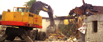
KILLING THE AMERICAN DREAM website, go HERE This is an update from the front line in the fight to preserve our Constitutional freedoms and protect our environment. Unfortunately things have not turned out well for us here on the eastern edge of the Everglades. Our community is called the 8.5 Square Mile Area. As some of you may know, we took the Corps of Engineers to federal court because they refused to protect our community as Congress "authorized and directed" them to do in 1989. The Corps apparently feels that it can interpret legislative intent any way it chooses. The federal judge felt otherwise, and said the Corps was violating federal law by attempting to implement a part of the Modified Water Delivery Project that was intended to give my community flood protection. This option, called Alternative 6D, acquires, and floods half of our community. After the judge ruled the Corps' actions illegal, the Corps then went behind the back of its own authorizing committee, and added an amendment in last year's Department of Interior appropriations bill that gave them the authority to do what a federal judge had just ruled was illegal. Congressmen Richard Pombo and Don Young wrote a joint letter to the Speaker of the House demanding that this amendment be removed from the bill, but Governor Jeb Bush lobbied the issue in Washington, personally. Who is going to argue with the president's brother? I hope people will thank these two brave congressman for trying to help us. Currently, the Corps is not following federal condemnation guidelines in regards to acquiring homes, farms, and land in the 8.5 SMA. The Corps is not even following the Congressional directives listed in the legislation that enabled them to complete Alternative 6D. We are unable to hire a condemnation attorney to help us. Here in Florida, millions of acres of land are being condemned by the state for Everglades restoration. If the state is condemning your land, your legal fees are paid, no questions asked, by the state. No lawyer wants to take on federal condemnation cases for poor, rural farmers when there is so much money to be made from state condemnation. The Corps is set to begin bulldozing homes in a month, and there is nothing we can do. Another problem we are encountering is the Corps' refusal to provide the remaining community with flood protection. Despite the language in the authorizing amendment that states the Corps will provide the remainder of the community with flood protection, the Corps states they only have to provide the community with "flood mitigation" or "pre-project conditions." When asked to define what levels of ground water are considered pre-project conditions, the Corps states that it is the "1983 base condition." When asked to state what water levels constitute the 1983 base condition, the Corps has said publicly that they do not know! In effect, the Corps is saying that it does not know what the project it designed will do! Another problem is the way the Corps measures land elevation. For years I have complained that the land elevation maps published by Everglades National Park and the Corps for the 8.5 SMA are inaccurate. They show land elevations about 1.5 feet lower than other maps that have been in use for over 30 years. I have just found out that there are different standards for measuring sea level. The older vertical datum is called National Geodetic Vertical Datum of 1929 (NGVD). Federal agencies are moving towards adopting a new standard called North American Vertical Datum of 1988 (NAVD). NAVD is approximately 1.5 feet lower than the older NGVD. It appears that land elevation is being measured in NAVD. This would not be a problem, except that ground water is continuing to be measured in the higher NGVD. I spoke to one of the Corps' computer modelers and asked him which vertical datum was used to measure land elevation in the models he was running for the 8.5 SMA project. He did not know! He did say that all other Everglades restoration projects were using NAVD measurements in their computer models. I asked him where he got the ground water elevation data for the models, and he said it was downloaded from the South Florida Water Management District web site. This data is in NGVD. I asked him how he converted this data to NAVD and he was unable to provide an answer. It appears he had not even thought about it. These elevation differences may not sound significant, but they are. If land elevation is measured using vertical datum that is 1.5 feet lower than the vertical datum used to measure the elevation of the water table, then it will appear that the ground water will be 1.5 feet higher than it really is. In other words, it will look like the 8.5 SMA will have ground water 1.5 feet higher than it will, in fact, have. It will also make it look like protecting the entire community will have a greater hydrologic impact on Everglades National Park than it will really have. Of course, any modeling done without reconciling the elevation data will be inaccurate. Community residents support Everglades restoration, but using junk science to justify taking private property that is not needed for restoration will accomplish nothing. The Everglades is being harmed, at the same time that our homes are being bulldozed! We don't know what to do or where to turn! Please pray for us! Madeleine Fortin,
President
|
Home
Page Updated: Saturday February 25, 2012 02:34 AM Pacific
Copyright © klamathbasincrisis.org, 2004, All Rights Reserved