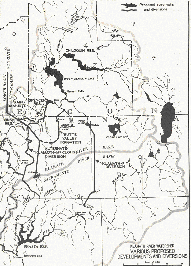
PROPOSED PLANS
ARMY CORPS OF ENGINEERS PLAN
From
50 Years On The Klamath
by John C. Boyle
Diversions to
Pitt
River
Plans for full utilization of
Klamath River for irrigation
and power were discussed many times in the past by
the Army Corps of Engineers, the Forest Service, the
Bureau of Reclamation and others, and exhaustive
reports were filed .
In
December 1944 the Civil Works Division of the War
Department detailed investigations covering water
and power utilization in the Klamath and
Pitt
Rivers
. The proposed plans were briefly:
(1) The construction of a high dam on the Sprague
River above Chiloquin that would flood the entire
Sprague River basin and store seasonal runoff to the
amount of 1,200,000 acre feet. This water would be
released through the
Upper Klamath Lake , through
Link
River
, through
Lost
River
diversion canal to
Tule
Lake
. From the lower end of Tule Lake there would be
constructed a tunnel, approximately 39 miles long,
to the headwaters of the Pitt River where it could
be utilized by the five plants of the Pacific Gas
and Electric Company, Shasta Dam, Keswick Dam, and
other places on the Shasta project, finally finding
its irrigation use in the Sacramento and San Joaquin
valleys. The water available was estimated at
900-second feet continuous flow throughout the year.
Canals and tunnels would be constructed for carrying
this quantity of water.
(2) All of the Klamath Irrigation would be supplied
from the
Williamson
River
,
Upper Klamath Lake , Horsefly
and
Clear
Lake
reservoirs.
(3) The
Tule
Lake
sump would be dried up and thereby permit the
reclamation of 22,000 acres of land for soldier
settlement. Water from the
Lower Klamath
Lake
could be returned to
Tule
Lake
without pumping, and water from the
Klamath River released into
the
Lower Klamath
Lake
area, with the result that the
Klamath River at Keno would
be dry for a considerable period of the year. During
the balance of the year the only water flowing in
the
Klamath River would be from
local areas below Horsefly reservoir or surpluses
above the storage capacity of
Upper Klamath Lake .
(4) An alternative line of diversion would be to
take the water from
Spencer
Bridge
below Keno around through the
Shasta
Valley
area to the
Mt.
Shasta
divide and cross over into the
McCloud
River
near the town of
Mt.
Shasta. While this diversion would reduce the tunnel
to about 9 miles in length, the water could not be
utilized in any of the Pacific Gas and Electric
Company plants. This diversion, however, would again
take all of the water out of
Klamath River and destroy all
the power projects below Keno with the exception of
the drop between Keno and
Spencer
Bridge
.
(5) The
inflow in the Klamath River below Spencer Bridge was
considered adequate to take care of fish life, and
the program called for utilization of Copco No.1
reservoir with storage of about 77,000 acre feet for
release of a continuous flow of water below Copco
No.1 to take care of fish life and recreational
facilities on the river below.
(6) The value of Copco No.1 and No.2 as power
projects would be totally destroyed. The plan
contemplated that Copco would continue to serve all
of the areas then served, and that Copco would be
reimbursed for its capital loss and furnished with
firm power at cost from the Shasta dam, with a
reasonable severance damage and assurance of
additional capacity if and when needed.
(7) The estimated cost of the project, including
losses to be paid Copco and others was
$100,000,000.00.
In December 1944 there was an explosion, which shook
both the Upper and
Lower Klamath
River basins
and caused a united front to immediately form to
stop the Army Corps of Engineers from diverting
Klamath Water to
Sacramento
Valley
. Some envisioned another Owens Valley versus Los
Angeles aqueduct wherein so-called surplus water
might become firm water and be lost forever to the
Klamath Basin.
On
February
16, 1945 , Copco advised the Army Corps
of Engineers that the diversion of Klamath water to
the
Sacramento
Valley
was not in the public interest. H. R. Document No.
181, 73rd Congress referred on page 41, section 115,
states:
"The proposed diversion, by removing most of their
water supply would practically destroy the value of
the existing power plants at Copco No.1 and Copco
No.2, and any rights that Copco may have for the
construction of other plants on the Klamath. The
right to use the proposed 520 feet of power head
above
Trout
Lake
would compensate the power company for only a part
of this loss."
Public hearings were held at
Klamath Falls
, Yreka and
Eureka
where the proposed plans were discussed by qualified
engineers and all expressions for and against the
program were recorded.
A legislative committee headed by State Senator
Randolph Collier made a valuable report summarized
as follows:
The California Legislature 56 session passed Senate
Concurrent Resolution No.18 Chapter 21, statutes of
1945 appointing a committee to investigate and
report its findings in connection with the
proposed Klamath and
Trinity River diversions to
the Central Valley of California. The committee of
nine with Senator Randolph Collier, Chairman,
promptly held meetings beginning in January 1945 and
by May 1945 had filed a detailed report to the
California Legislature.
Insofar as
Klamath River diversions were
considered the conclusions of the Committee were
briefly:
(1) "The investigations being conducted in regard to
the Klamath River diversions by the Corps of
Engineers, War Department, are untimely and uncalled
for and are not supported by any local interests
whatsoever."
(2)
"Preliminary studies indicate that further water
requirements of the Upper Klamath basin will make it
necessary to develop practically all of existing
water supply within the Klamath River basin."
And it was recommended that:
(1) "The Bureau of Reclamation should be requested
by local residents to investigate water requirements
of the entire Klamath River Basin giving full
consideration to the irrigation, power, fish, and
wildlife, recreational and other beneficial uses for
water."
(2) "Investigation by the Corps of Engineers should
be discontinued without further unnecessary
expenditure of public funds."
BUREAU OF
RECLAMATION PLAN
In June 1954 the Bureau of Reclamation completed a
preliminary study of the
Upper
Klamath
River Basin
covering development of water and related resources.
This study included reports from the Bureau of
Indian Affairs, Fish and Wildlife Service, National
Park Service, Bureau of Mines, Forest Service,
Bureau of Land Management and Bonneville Power
Administration. It was very complete in reviewing
the status of developments which had taken place to
date and it outlined a comprehensive plan for
utilizing the remaining resources of the basin for
the benefit of all interested agencies.
The important changes suggested in the plan were:
(1) To include
Shasta
River
Valley
and
Scott
River
Valley
in the
Upper
Klamath
Basin
where they were previously considered as part of the
Lower Klamath
Basin
.
(2) To include power development by the Bureau of
Reclamation by diverting
Klamath River by way of
Butte
Valley
,
Meiss
Lake
, and
Ikes
Mountain
tunnel to a powerplant at the upper end of
Copco
Lake
of about 105,000 KW capacity.
As
Meiss
Lake
could easily be drained back through the proposed
Butte
Valley
tunnel all the drainage flows of water from rainfall
and irrigation could be returned to the
Klamath River at Keno. The
proposed river level canal, similar to the
Lost
River
diversion canal, would permit water to be taken in
either direction.
The Bureau of Reclamation changed its plans with
respect to irrigating the
Butte
Valley
and the diversion of water through
Butte
Valley
to
Shasta
Valley
or
Copco
Lake
because it was impossible to convince the irrigators
in
Butte
Valley
that the high cost per acre for water was justified.
Some of the area in
Butte
Valley
and
Red
Rock
Valley
was irrigated from ground water supply and the
irrigators refused to surrender their water rights
to the
United States
to become a part of the
Butte
Valley
and Red Rock system. Also considerable land in
Butte
Valley
was alkaline, and reclamation of this land was
questionable.
THE COPCO PLANS
Canyon Project
Power development in the
Upper
Klamath
Basin
canyon was considered very important to Copco. It
already had large investments in power plants on the
river so it kept constantly in touch with the river
and its utilization.
Copco's
plan followed very closely the requirements of the
Federal Power Commission, namely that an application
must include a proposal to develop and utilize all
the power re- sources of the area.
On May 9, 1921, application was made to the Federal
Power Commission for permission to investigate a
stretch of river about 10 miles in length lying in
Oregon immediately above the state line, for the
purpose of the ultimate development of about 320,000
KW between Keno and Iron Gate. The Federal Power
Commission issued a permit No.215 on
November
27, 1922 under which engineering studies
could be made.
On May 12, 1921, application was made to the State
Engineer of Oregon to appropriate 1500 second feet
of water for the development of 7.0,000 THP
(theoretical horsepower), application No.7894, on
this same stretch of river. Permit was not issued by
the State Engineer for the reason that the Attorney
General of Oregon had rendered an opinion that those
waters were not subject to appropriation having been
transferred to the
United States
for irrigation purposes under Oregon Legislative Act
of 1905.
As time passed, engineering studies were completed
and the preliminary layout of projects submitted
with revised applications to the Federal Power
Commission and the State Engineer of Oregon.
The original state filing No.7894 was changed and
new filings made as follows:
Canyon Project No. 13603- 28,295 THP
Big Bend No. 13604- 65,455 THP
original No.7894
Grant No.2 No. 13605- 36,477 THP
Grant No.3 No. 13606- 17,045 THP
Grant No.4 No. 13607 -34,091
THP
181,363
These applications were before the State Engineer
for approval and Copco asked that the Canyon Project
be approved for construction. The Company had
appropriated $4,000,000.00 and had received a
preliminary license from the Federal Power
Commission. This preliminary license was recalled
when the FPC was advised that Copco had not been
granted a permit for use of the water from the
state.
Legal questions arose as to whether or not the state
"could issue any permits for appropriation of any of
the waters within the
Klamath River or the
Klamath
Lake
basins." The State Engineer advised that permits
pending would not be approved by the State
Reclamation Commission until a license was obtained
from the Federal Power Commission. A hearing was
held before the State Reclamation Commission on
October l0th, 1930 in
Salem ,
Oregon
. Protests were filed for and against issuing a
permit. The Commission sought to determine whether
or not water appropriated would impair or be
detrimental to the public interest. Eighty seven
pages of testimony were taken. Finally, it was
proposed that a bill (S-315) be introduced in the
January 1931 session of the Oregon Legislature for
the purpose of clarifying the matter of water rights
below Keno. State authorities, lawyers, and public
officials prepared the bill. It passed both houses
but was vetoed by the governor.
The governor and his staff delayed further action
until the act creating the Hydroelectric Commission
of Oregon had become effective.
The Hydroelectric
Act of
January 22, 1931
provided for a commission within
the State of
Oregon
similar to the Federal
Power Commission. It had jurisdiction over the water
power resources of the state and required that all
pending applications for the development of power be
referred to the Commission within 60 days. The State
officials were contemplating going into the
development and marketing of power.
Copco did not transfer its applications on the
Klamath River to the new
commission because there still remained considerable
uncertainty about water rights. So the State
Engineer canceled the pending applications and
advised that if renewed, they would have to come
under the new Hydroelectric Commission of Oregon,
stating that Copco had lost their priority and that
the only way they could regain that priority would
be through litigation.
The Company then transferred its activities to the
Iron Gate site in
California
on the
Klamath River and decided to
use the $4,000,000.00 approved for the Canyon
Project on
Iron Gate development.
The applications to develop the
Iron Gate site filed with the
Federal Power Commission and the State of
California
again brought up the old problems of water rights.
Legal and legislative procedures involved not only
the waivers in favor of irrigation in
Oregon
but extended them also to
California
. These waivers plus the question of interstate
rights plus the question of prior rights to use of
water at Copco No. 1 and Copco No.2 in
California
were discussed in several conferences but no
satisfactory agreement was reached, so the
Iron Gate project was
indefinitely postponed early in 1932.
The
Klamath River and that part
of the
Upper
Klamath
Basin
between
Link
River
and Keno changed in many respects with the
development of irrigation and power:
In 1890, a dike was built to prevent overflow of
Klamath River with
Lost
River
and on into
Tule
Lake
. This dike was cut by the
Lost
River
diversion canal when built in 1911-1912 thus
eliminating a relief of
Klamath River water during
floods. Also
Tule
Lake
area was dried up for reclamation by diverting
Lost
River
into
Klamath River . These two
changes modified the flow of
Klamath River at Keno and
below.
In 1906 and 1907, the Southern Pacific Railroad was
required to install headgates at Ady so flow of
water to and from
Lower Klamath
Lake
could be regulated or shut off entirely. On
October
12, 1917 the headgates were closed to
accomplish drying up the
Lower Klamath
Lake
. Here again the natural process of lake regulation
of
Klamath River was lost and
the flows of water below Keno materially changed.
In 1919, with the beginning of regulation of the
Upper Klamath Lake , the
regulation and control of water levels in the
Klamath River between
Klamath Falls
and Keno became a serious problem. The
Klamath River meandered
around through swamp and overflowed lands for about
20 miles between
Klamath Falls
and Keno with a drop in water surface elevation of
only one to three inches under normal flow
conditions. About 15,000 acres of land could be
affected by the fluctuations of the river. About
10,000 acres of this land had been diked, again
adversely affecting natural flows in the river at
Keno,
No particular problem occurred until 1927 when a
large discharge in
Klamath River allegedly broke
a dike and flooded several thousand acres of diked
land.
The Bureau of Reclamation had in mind enlarging the
Lost
River
diversion canal to carry more than the original
250-second feet, to better protect
Tule
Lake
lands and it needed better control of the water at
Keno reef. So the Bureau and Copco in a contract of
July 3, 1930
provided that Copco would build a regulating dam at
Keno reef and in so doing occupy part of the
McCormick power site. Before work was started some
50 riparian landowners were required to give Copco
releases from damage if water levels in the river
were maintained within specified elevations.
A needle dam was completed
December
12, 1931 . Prior to this date it took two
to four days for releases of water from
Upper Klamath Lake to reach
Copco No. 1. By opening the new dam at Keno
simultaneously with the gates at
Link
River
dam, this time lag was cut to about 12 hours. And
the Lost River Diversion canal became a "water level
canal" wherein water up to 3000-second feet could be
conveyed from
Lost
River
to
Klamath River or
Klamath River to
Lost
River.
Langell Valley Lands
In 1924, a year of extremely low water, Copco needed
additional water for generation of power at Copco
No. 1 power plant.
Clear
Lake
reservoir had a surplus carry-over from preceding
years of about 100,000 acre-feet. This water was not
needed presently for the Langell Valley Irrigation
District or for other users supplied from that
source.
Arrangements were made with the Bureau to purchase
60,000 acre feet at $.20 per acre foot with the
responsibility on Copco to run it through
Langell
Valley
,
Lost
River
and the
Lost
River
diversion canal into the
Klamath River above Keno.
The old original channel of
Lost
River
through the floor of
Langell
Valley
would not carry sufficient water without flooding
about 6000 acres of the valley. The result was the
purchase of a release from damages to hay and
pasture lands from the landowners plus the loss of
profit on some 858 range cattle nominally wintered
in the valley. The net cost to the company for this
water was about $.60 per acre-foot.
The Langell Valley Irrigation District board in 1926
planned to have the Reclamation Service construct a
drain through the valley at an estimated cost of
$50,000.00, but were un- able to obtain right of way
over the Swingle property. It was suggested that
Copco acquire this land, grant the right of way to
the district, and in consideration receive from
the district a contract permitting future use of the
drainage ditch by the company.
This was done. The necessary improvements were made
and Copco obtained the right to pass water over the
diversion dam of the district, through
Langell
Valley
into
Lost
River
should the purchase of water again become necessary.
Here again natural runoff of water was changed.
Big Bend
Project
Copco made no power developments in the
Klamath
Basin
after 1924 on
Link
River
, and 1925 on
Klamath River at Copco No.2.
It had however kept up with its load growth by
developing power elsewhere, at:
Prospect 2,3 and 4 on the
Rogue River
40,200 KW
4 Diesel
plants
1,035 KW
Alturas
hydroelectric
450 KW
Toketee - 8 plants on the
North
Umpqua
River
(2 under
construction)
200,000 KW
Total 241,685 KW
Upon completion of the last of the Toketee plants by
1956 other plants needed to be constructed shortly
thereafter. In the early '20s Copco system load
increased at about 4,000 to 5,000 KW per year. By
1957 this increase jumped to about 10,000 and 15,000
KW per year.
So filings were made on the
McCloud
River
on
January 9,
1952 with the Federal Power Commission
for development of about 250,000 KW there.
However,
Klamath
Canyon
was most attractive, being near the Copco load
center where construction cost and transmission
lines would be minimum. It was therefore decided to
make another attempt to secure necessary water
rights in
Oregon
sufficient to justify construction.
The creation of the Hydroelectric Commission of
Oregon in 1931 with amendments of the Legislative
Act made it possible for a power company to obtain a
license similar to a Federal Power Commission
license for use of water in
Oregon
, for power purposes. Such a license could be
obtained for use of water in the
Klamath River without
conflicting with the water rights of the U. S.
Government and other irrigationists.
In 1951, the Klamath community was advised that a
power plant would be built on the
Klamath River below Keno if
it was unanimously approved by all interested
parties of the Klamath basin.
On
February
15, 1951 , Copco authorized applications
to the Federal Power Commission and the
Hydroelectric Commission of Oregon to construct the
Big Bend Plant on
Klamath River 6 miles below
Keno.
Because of the need to construct larger power
developments adequate to meet the system demands,
the plans were changed to combine two of the
original projects with one of 88,000 KW capacity.
The purpose of applications at this time, perhaps
four or five years in advance of need, was to
determine what if any legal complications would
arise which would delay the development or make it
impossible to construct the plant. Based upon the
experiences during 1925 to 1930 in Klamath regarding
water rights, the outlook was not optimistic.
A plan was submitted covering development of the
remaining undeveloped projects between Keno and
Iron Gate and it incorporated
additional storage at
Aspen
Lake
. Applications to the Federal and State Commissions
were mailed on
April 16,
1951 .
Practically all the irrigation districts in the
Klamath Reclamation Project joined in filing
protests. The Secretary of Interior filed a protest,
as did the Bureau of Reclamation and many
individuals.
During the following months some resolutions
favoring the project were filed. The Oregon State
Federation of Labor at convention in
Klamath Falls
June 29,
1951 was an important one.
The deadline date for filing protest with the
Federal Power Commission was
July 19,
1951 . Some extension of time was given
by the Hydroelectric Commission of Oregon.
On Friday, September 7, 1951, the State
Hydroelectric Commission stated that no further
hearings would be held and it was satisfied that if
Copco could work out an agreement with the
Bureau of Reclamation for an extension of the
contract to regulate the Upper Klamath
Lake and presented it to the
State Commission, no further questions would be
raised over issuance of a state license to use the
water.
Hearings were held
before the Federal Power Commission on June 3 and 4,
1952 and
June 30, 1952
. Fifty-seven exhibits were filed
and oral testimony was taken. Another hearing was
held in Yreka on
September 5, 1952
. Progress seemed slow
and time was running out.
So on
May 18,
1953 , Copco asked the Secretary of
Interior and the Bureau of Reclamation to withdraw
their protests and consider extending the
Upper Klamath Lake contract
for the license period established by the Federal
and State Commissions.
In May 1953 Copco completed negotiations with the
Bureau of Reclamation to purchase the output of the
Bureau's new 18,500 KW Greensprings plant on the
system of the Talent Irrigation District (
Upper
Klamath
Basin
).
On
January 7,
1955 the Secretary of Interior authorized
negotiations on an extension .to the contract of
February
24, 1917 .
On August 5, 1955, the draft of a contract between
the Department of Interior and Copco covering
regulation of Upper Klamath Lake, pumping rights for
the Klamath Project, water uses and other associated
provisions were submitted to all interested parties
and comments requested by September 1, 1955. If a
contract was signed, copies were to be filed with
the Federal Power Commission, Hydroelectric
Commission of Oregon and the Public Utility
Commissions of Oregon and
California
. Approval of these four commissions and the Bureau
of Reclamation must be obtained before construction
work could be started. Copco's revised plans
provided for additional power developments to those
proposed in the original filings. Total estimated
cost, about $70,000,000.00. (See article in
Electrical West May 1960.)
In a meeting in Sacramento September 28, 1955, a
letter from Copco to the Oregon and California River
Compact Commissions stated in part "that no Klamath
water shall be used by Copco when it may be needed
or required for use for domestic, municipal, or
irrigation purposes within the Upper Klamath River
Basin as defined in the compact; Provided nothing
shall curtail or interfere with the water rights of
Copco having a priority earlier than May 19, 1905;
Provided further that all drainage and return flows
shall be at a point above Keno."
The new agreement between Copco and the Bureau of
Reclamation was completed January 3l, 1956. Work was
authorized to start in June 1956 and Copco had
obtained the unanimous support originally requested
in 1951.
The
Big Bend project was rushed
to completion and 88,000 KW were added to the Copco
system by October I, 1958
.
Big Bend
Development
Dam: The dam is located on the
Klamath River about one mile
downstream from the bridge crossing of Oregon State
Highway No.21. It is an earth fill type with clay
core wall, overall crest length 692.6 feet, a crest
width of 15 feet and is 68 feet above the stream
bed. The earth fill section is 413.5 feet, spillway
section 117.0 feet, intake section 48.5 feet and
gravity section 113.6 feet. Crest elevation is
3,800.0 feet.
Reservoir: The reservoir capacity is 3,377
acre-feet, 1,397 acre-feet of which will be usable
pondage. The normal water surface elevation is
3,793.0 feet with a normal low water surface of
3,788.0 feet. The reservoir extends upstream for a
distance of approximately 3 miles.
Tunnel: 74.50 feet -steel lined -16-foot
diameter.
1,587.72 feet -concrete lined -16-foot
diameter, horseshoe shape.
Waterways: 15.25 feet of concrete intake.
638.41 feet of 14'0" I.D. steel pipe
crossing the
Klamath River on concrete
piers.
49.59 feet of 14'0" concrete conduit.
36.00 feet of concrete transition.
6,271.62 feet of two wall concrete flume.
4,489.13 feet of one wall concrete flume.
340.00 feet of concrete forebay.
1,587.72 feet of concrete lined tunnel -16'0"
diameter
74.50 feet of steel lined tunnel -16'0" diameter
(to the centerline of the surge tank.)
Total length -2.56 miles.
Penstock: The surge tank at the upper end of
the penstock is 56.0 feet in height and 30 feet
in diameter (I.D.). The twin steel penstocks are
957.68 feet in length (true dimension, centerline of
surge tank to centerline of unit, with inside
diameters varying from 10'6" to 9'0" and plate
thicknesses varying from 3/8" to 15/16".
Head and Diversion. Maximum static
head -454 feet.
Normal net
effective head -440 feet.
Normal diversion
-2,500 cubic feet per second.
Power Plant: The power plant consists of two
General Electric vertical generators each 42,100 KVA,
95% power factor, 3 phase, 60 cycle, 11,500 volt,
277 R.P.M. Nameplate rating 79,990 KW. The two
Baldwin, Lima, Hamilton Corporation turbines are
rated 56,000 H.P. each and are equipped with Pelton
Type B Hydraulic governors. Capability is rated at
88,000 KW.
Substation: The power generated at 11.5 KV is
transformed to 230 KV by two General Electric 42,300
KV A, 3 phase transformers which, together with the
associated electrical equipment, are located
adjacent to the power plant.
Transmission: A 230 KV transmission Line
No.59 connects the plant with the Company's existing
system at
Klamath Falls
and
Medford ,
Oregon
. The length of this line is 69.9 miles and consists
of wood two pole H frame structures, 40' steel
crossarms, with 3-795 MCM ACSR conductors strung for
heavy loading.
Iron Gate
Project
The
April 16,
1956 application to appropriate water at
Iron Gate was filed with the
State of
California
. The permit from the State provided that "water
uses at Iron Gate and the river below are subject to
irrigation needs of Shasta Valley, namely, until
March 1, 2006 -120,000 acre feet annually and
ultimately 220,000 acre feet annually "
On
January 18, 1960
advice was received that a
license for the
Iron Gate
project on the
Klamath River
had been approved by the Federal
Power Commission.
Iron Gate
was completed and put into
service
January 13, 1962
.
Iron Gate
Development
Dam: The dam is located on the
Klamath River approximately 7
miles below the existing Copco No.2 power plant, in
the Southwest 1/4, Section 9, Township 47 North,
Range 5 West, Mount Diablo Meridian. It is an earth
fill type with compacted clay core, concrete cutoff
wall and grout curtain at base. The length at crest
is approximately 685 feet and the height above
stream bed is 173 feet. Crest elevation is 2,338
feet U.S.G.S. datum. The spillway is a free
overflow, side channel type with a capacity of
32,000 cubic feet per second.
Reservoir: To be operated essentially as a
re-regulating reservoir. The reservoir capacity is
approximately 58,000 acre-feet. The normal operating
water surface elevation is 2,328 feet with a normal
low water surface elevation of 2,324 feet.
Tunnel: A 16-foot horseshoe shape tunnel,
969.2 feet in length under the right abutment of the
dam. Will serve as a sluice and diversion during
construction.
Penstock: 12-foot I.D. steel pipe through
dam. Length -681.26 feet.
Head and Diversion:
Normal Static Head -158 feet.
Normal Net Effective Head -154 feet.
Normal Diversion
-1,650 cubic feet per second.
Power Plant: One vertical reaction turbine
rated at 25,000 H.P., direct connected to an 18,000
KW generator.
Substation: A substation adjacent to the
powerhouse will contain a 3-phase transformer
capable of stepping up the generator output voltage
to 66 KV.
Transmission: A transmission line of standard
wood pole construction will connect the sub- station
with the applicant's existing transmission system at
the Copco No.2 switchyard.
Roads: The reservoir will inundate some of
the existing county road and approximately 61/2
miles will be relocated by the company. Upon
completion of the project, the new road will be
owned and maintained by the county.
Fish Facilities: In conjunction with the
State of
California
, Department of Fish and Game, the company will
provide a fish ladder, holding tanks, water pipe
lines and egg taking facilities at the downstream
toe of the dam. These facilities will be constructed
to State specifications, and upon completion, will
be owned and operated by the State.
Iron Gate dam, part of the
Copco plan, dedicated
February 3,
1962 , is an important milepost in the
history of Klamath Water.
It was built where the iron colored bedrock stood
almost vertically 250 feet above the river, and
served as a control point.
It had iron
eyebolts drilled securely in the bedrock to hold log
booms, which impounded and released logs from
upstream as needed for the sawmill at Klamathon
below.
It controlled the one-way county road cut in a
bedrock shelf frequently subject to overflow.
It controlled the Klamath Lake Railroad at its
five-mile post where a mile of 4% grade had to be
built adverse to upstream freight hauling.
It marked the control of water surface fluctuations
caused by load changes at Copco No.2 powerhouse,
which had affected the river below.
It marked the end of fish migration from the
Pacific Ocean and the
construction of facilities for artificial
propagation.
It marked the time when the States of California and
Oregon
solved the intricate problem of interstate water
rights by creating a compact commission ratified by
Congress to "promote the orderly, integrated and
comprehensive development use, conservation and
control of water in the
Upper
Klamath
Basin
in
Oregon
and
California
."
SUMMARY
The Bureau of Reclamation and Copco continued to
make studies relative to the value of additional
storage of water at
Steel
Swamp
,
Clear
Lake
, Boundary and elsewhere. Also the downstream
benefits which might accrue from power to warrant
further irrigation developments were calculated. As
in the beginning there were so many diverse opinions
on the further use of Klamath Water that time passed
with very little progress being made.
Fifty years had passed during this application of
water to about one-half of the 600,000 acres of
agricultural land, which could be eventually
irrigated in the
Upper
Klamath
Basin
. It was reliably estimated that it would take
another 75 years to complete the irrigation program.
It also had taken 50 years for the development of
about one-half of the potential hydro- electric
power (320,000 KW) in the
Upper
Klamath
Basin
below Keno.
The two, irrigation and power, developed parallel to
and complimented each other.
Twenty years have now passed since the joint venture
between the Department of Interior and Copco, which
started
February
24, 1917 , was extended to the year 2006.
Those interested in retaining and developing
Klamath's greatest natural resource, "Water," should
not be complacent. Who knows when somebody with
plenty of money and plenty of votes may appropriate
part of it and put it to beneficial use outside the
basin of its origin? It is still the envy of much of
the arid West.
On
June 21,
1961 Copco was merged with Pacific Power
& Light Company. At the dedication of
Iron Gate on
February 3,
1962 Pacific Power surprisingly announced
that its directors had decided to rename the Big
Bend Plant on the
Klamath River below Keno.
Rededication was held on
June 25,
1962 at the Big Bend Powerhouse and a
luncheon was served at the Winema Hotel in
Klamath Falls
. At that time a pamphlet distributed to the public
contained the following announcement:
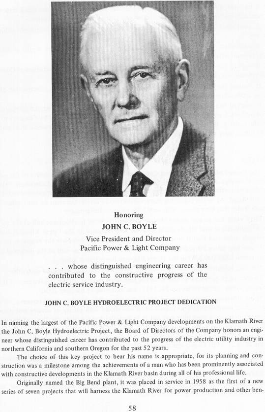
efits for residents of the area. It typifies
the scope of the vision of John C. Boyle and the
contributions he has made to the long-range planning
for the full use of the water resources of the
basin.
A native of
Siskiyou County
,
California
, he began preparing for the
profession of his choice at the
University
of
California
, and received his
degree in civil engineering in 1910. Since then he
has been employed as an engineer and construction
superintendent and in management and executive
positions by Pacific Power and the predecessor
electric companies that have served the area.
John C. Boyle's first job was field surveying for
the Siskiyou Electric Power & Light Company. It led
to his assignment in 1916-1918 as the superintendent
of construction of a 135-foot- high dam and the
20,000-kilowatt Copco No.1 powerhouse by a successor
company, The California Oregon Power Company, at a
site he had located during his first survey work.
The concept of providing for regulation of Upper
Klamath Lake and reclamation of marsh lands was made
feasible a few years later when he completed the
engineering and building of the Link River Dam in
Klamath Falls. Together with related channel
dredging and diking, the dam has made it possible to
greatly expand the basic agricultural economy of the
region.
During the decades of the 1920s and 1930s, he
devoted his engineering talents to building the
modern electric power system that has served the
growing area so well. In this period he also
investigated the hydroelectric potential of the
Klamath, Rogue and
North Umpqua river basins.
From these studies Boyle developed in the 1940s and
1950s the plans for the future use of sites
providing the most economical power supplies
available for the Company's customers.
Mr. Boyle became the Vice President and General
Manager and Chief Engineer of The California Oregon
Power Company in 1941. Beginning in 1945 he guided
the Company into a decade of record expansions of
its generating capacity. The work centered on the
North
Umpqua
River
, a region of deep canyons and timbered mountains,
where the formidable construction problems posed new
tests of his engineering knowledge, experience and
judgement. A unique project, its eight plants are
designed to use repeatedly the limited flow of the
river in a stair-step series of remote-controlled
turbine-generators. The achievement won an accolade
from the Professional Engineers of Oregon, who named
him
Oregon
's Engineer of the Year for 1951.
While completing the
North Umpqua project, he
reviewed his earlier surveys of the Klamath and
other rivers. These studies looking to future
developments, and a new agreement with the Bureau of
Reclamation for the continued operation of the Link
River Dam as the regulator for
Upper Klamath Lake resulted
in the start of work in 1956 on the project that
hereafter will bear the name of John C. Boyle.
It is very appropriate that a dynamic and useful
development such as this hydroelectric project
should carry his name in recognition of his
outstanding engineering services to the Company and
as a testimonial to the qualities of leadership he
has given to the task of building the region it
serves.
Presented to Luncheon Program Guests
Winema Hotel,
Klamath Falls ,
Oregon
June
25, 1962
|