Preface And Klamath River
Basins
From 50 Years On The
Klamath
by John C. Boyle
In the records of trappers, explorers and trail blazers, many
references were
made to the lakes, rivers and mountain streams in the Klamath
country. Most of the
settlers who followed these men were headed for the
Sacramento
or the
Willamette
Valley
or the mining districts in between. Only a few who had no quarrel
with the
Indians remained and took up homesteads or purchased swamp and
overflowed land from
the government.
The country was wide open for stock raising with plenty of free
pasture and range lands.
In some localities, settlers obtained large holdings, and claimed
lands best suited for their
purposes. Streams were diverted for irrigation, dikes were built
to protect lands from overflow
and means sought to get rid of surplus waters. Each settler had
his own idea about water,
often different from that of his neighbor, which lead to
misunderstandings, ill feelings, and lawsuits.
The citizens in the Klamath communities realized that water was
the greatest asset of the
area. When efforts were made to divert it elsewhere, they
unanimously maintained the
position that all the water was needed for the ultimate
development of the basin of its origin.
At the turn of the century when irrigation and power engineers
visited the area, they generally
agreed that if properly conserved and utilized, there was enough
water to supply every need
which might locate in the
Klamath
Basin
. This conclusion still holds true in 1976.
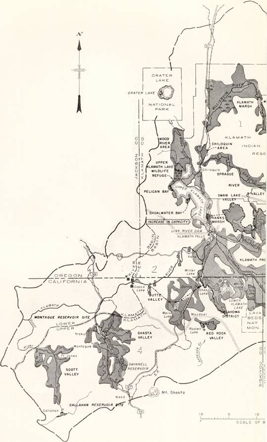
KLAMATH RIVER BASINS
As
Klamath River
is an interstate stream, the question of water rights in
Oregon
and
California
and the use of water in each state has been an unsettled
matter for many years.
Oregon
had put to beneficial use water for irrigation long before
the U.S. Bureau of Reclamation started its Klamath Irrigation project in 1905.
California
had used water beneficially for mining, irrigation, and
development of power from the days of early settlement in
Northern California
. The total drainage area, estimated at 15,500 square miles
not including the Trinity River basin, supplied sufficient water for both states
if put to beneficial use within its basins.
The
Klamath River as it left the irrigated areas above Keno,
Oregon
, dropped about 4100 feet in almost 250 miles into the
Pacific Ocean . Throughout this distance it flowed
primarily into a canyon with steep narrow sides, with very little flow through
lands, which were or might be irrigated.
Power sites were numerous
between Keno and the
Pacific Ocean . The most attractive of these were in the
first fifty miles of the river below Keno where the fall in the river is about
2500 feet, with lake regulation and storage reservoirs at the source.
In-flow streams like Willow Creek, Shasta River, and
Scott River, all tributary to Klamath, had areas of agriculture land, which
needed supplemental irrigation water, and looked to the Klamath as the principal
source of supply.
The Bureau of Reclamation, the
Oregon
and California Klamath River Compact Commission, and the California Oregon Power
Company (Copco) each divided the
Klamath
River basin
into two parts, the
Upper
Basin
and the
Lower
Basin
.
Upper
Klamath
River Basin
The Bureau of Reclamation defined the
Upper
Klamath
Basin
as an area drained by the
Klamath River and all its tributaries above Copco No.2.
This was done for the purpose of including any diversion of water into
Butte
Valley
and
Shasta
Valley
for irrigation in those valleys.
The
Oregon
and California Klamath River Compact Commission designated
the
Upper
Klamath
River basin
as that portion of the basin tributary to the
Klamath River
above the Oregon-California state line. Portions of this area
in
California
included
Butte
Valley
and
Red
Rock
Valley
drainage, which flowed northerly and was used for irrigation
in
Oregon
. Some of the arid lands in
California
receive irrigation water from tributaries of the
Klamath River
in
Oregon
. Each state retains its sovereignty.
The California Oregon Power Company expected to develop all
the power resources of the
Upper
Klamath
River basin
to and including
Iron Gate ,
so they determined the boundaries of the
Upper
Klamath
River basin
as all the drainage areas above
Iron Gate .
In using the
Upper Klamath Lake for storage and creating additional
reservoirs in the
Upper
Basin
, it was generally agreed by all interested agencies that the use for irrigation
within the
Upper
Klamath
Basin
had a priority over the use for power purposes. And it was agreed that all
drainage flows within the
Upper
Klamath
Basin
would be returned to the
Klamath River above Keno. The only diversions permitted
to go outside its basin would be the diversions from
Four
Mile
Lake
to the Medford Irrigation District and the diversion of
Jenny
Creek
to the Talent irrigation District on
Greenspring
Mountain
.
Lower Klamath
River Basin
. The
Lower Klamath
River Basin
included the
Klamath River and all its tributaries between
Iron Gate and its confluence with the
Pacific Ocean . This part of the basin included
Shasta
Valley
and
Scott
Valley
as the areas most likely to be developed by irrigation. The balance of the area
needed very little water for the lands, which may be irrigated, and, because of
its canyon walls and rough terrain, it had been established as a fish and, game
district by legislative act of
California
,
December 17, 1924 . This
act also prohibited the construction of any dam or other artificial obstruction
below the confluence of the
Klamath River and the
Shasta
River
.
There are at least ten dam sites along the
Klamath River between Iron Gate Dam and the mouth of the
river, none of which were developed. They were chosen by different engineers at
different times and made the subject of exhaustive reports.
On a 1910 reconnaissance by Copco, only two of these were
mentioned as desirable, No. 1 at
Big Bend , four miles upstream from Happy Camp, and No.2
at
Ishi
Pishi
Falls
, just above the mouth of the
Salmon River .
The No. 1 site could be developed to produce about 30,000 KW
under a 100 foot head and about 45,000 KW under a 150 foot head, with a tunnel
length of about 3500 feet through the ridge which forms the big bend. The river
grade resulted in a fall of about 55 feet around
Big Bend . A small dam diverting the river to utilize
only the 55-foot drop could develop about 15,000KW.
A low level tunnel was proposed during the gold mining days to
unwater this five or six miles of river to placer mining but was never developed
because high head diversions from Thompson Creek and Indian Creek were better
used for hydraulic mining.
The flexibility offered in this project fit well into Copco's
plans to develop units of production which would serve the need of the
surrounding area. The transmission lines of the company were extended down the
Klamath River from Yreka to Grey Eagle mine and from Cave
Junction in
Illinois
Valley
to Happy Camp having in mind that a power plant at
Big Bend , in addition to serving the surrounding area,
would feed back to the company’s transmission system any surplus generation.
The site at
Ishi
Pishi
Falls
was probably the lowest cost per KW of any of the proposed developments on the
Klamath River below
Iron Gate . The foresight of Frank Langford and his
associates is commendable. He initiated water rights in 1908, obtained rights
of way and started extensive construction work. The amount of power he expected
to develop was flexible, starting with about 25,000 KW and ultimately developing
perhaps 200,000 KW, including waters from the
Salmon River . His problem was finding a market for his
power.
The territory immediately adjacent was sparsely
settled so he envisioned transmitting power to
Trinidad harbor for the production of aluminum, copper
and other electro-metals.
Application No.74 before the Federal Power Commission by the
Electro-Metals claimed rights from filings made in 1905.
The development of irrigation in
Scott
Valley
, like
Shasta
Valley
and others, was on a partial basis wherein certain areas were irrigated by
gravity or by pumping depending on the justified costs. Copco was interested in
the pumping developments as an outlet for sale of power. Therefore activity
engaged in studies and estimates for the benefit of those who requested such
service.
A review of many studies for
irrigating
Shasta
Valley
was made beginning with the James M. Davidson survey in 1892 and ending with the
California Department of Water Resources studies in 1963. There were found to be
37 engineering reports (see appendix B) together with comments, most of which
related to water for additional irrigation in Shasta Valley from Klamath River
as an outside source.
In all these studies, no one indicated that surplus waters of
Scott
Valley
could be used not only to irrigate an additional 30,000 acres in
Scott
Valley
, but could supply enough water to irrigate an additional 40,000 acres in
Shasta
Valley
.
Preliminary studies show that with a dam below the mouth of
Shackleford Creek, a pumping plant to pump water to a storage reservoir on
Moffatt Creek, and a tunnel to Yreka Creek all of these 70,000 acres could be
irrigated and supplemental water supplied to both valleys.
The average seasonal run off of
Scott
River
below Shackleford Creek for a 20-year period was about 460,000 acre feet and the
minimum run off of record 172,000 acre feet after diversion for lands now
irrigated.
Estimated
Scott
Valley
additional needs 60,000 acre-feet
Estimated
Shasta
Valley
additional needs 80,000 acre-feet
140,000 acre-feet
Excess average minimum run off above needs of both Valleys
-32,000 acre-feet.
UPPER
KLAMATH
RIVER BASIN
. Keno was the control point in the
Upper
Klamath
Basin
where the
Klamath River left the agricultural land and regulating
lakes and started down the canyon through the
Cascade Mountains on its course to the
Pacific Ocean . Keno has also been marked as the point of
division between irrigation and power, however diversions for irrigation were
proposed at points below Keno.
McCormick Site. On
February 20, 1906 an
agreement was made by the Reclamation Service with Thomas McCormick for purchase
of water rights and rights of way for building a cut in the Keno reef for
lowering the
Klamath River , possibly lowering
Lower Klamath
Lake
and providing a better discharge channel for waters from the proposed
Lost
River
diversion canal. The McCormick site was a strip 400 feet wide, 9000 feet long on
the south and west bank of the Klamath River, including power development
possibilities in this strip of 68 feet fall.
Deed executed
November 14, 1906
. Consideration $10,000.00
Bureau of Reclamation. During March and April 1906,
the Reclamation Service made preliminary surveys of the power possibilities
below Keno (McCormick Site) to
Beswick ,
California
. In the distance of about 28 miles it recorded an average drop of 51 feet per
mile and in some places 100 feet per mile. All public lands between Keno and
Klamathon ,
California
, bordering the river, were then withdrawn from public entry and reserved for
power development. No water filings were made by the Reclamation Service at that
time.
Southern Pacific Power Site. The property acquired
by the Southern Pacific Railroad Co. was purchased from it by Copco in 1921. I t
had a possible diversion dam site at the old crib dam and bridge on the Klamath
River six miles below Keno. The Southern Pacific had made preliminary
investigations and had excavated a bench along the north side of the river about
three quarters of a mile long, which could be used in connection with any power
development planned by that company.
It was assumed that this site together with
a site on the North Umpqua River and one on the Willamette River, were part of a
program to electrify the railroad from Redding, California to Eugene, Oregon if
and when such a railroad was built.
Southern Oregon Water Company. A proposed
development was that of the Southern Oregon Water Company who owned considerable
of the riparian lands between Keno and the California-Oregon state line, about
1300 acres.
The
incorporators of the Southern Oregon Water Company were mostly men connected
with the Long-Bell Lumber Company. The lands were subsequently transferred to
Weyerhaeuser. No developments of power were made although the lands controlled
some of the important power sites.
Long-Bell Lumber Company was asked whether or not it intended to
develop power on its holdings. It had thought at one time that it might be
economical for Long-Bell and Weyerhaeuser jointly to develop power and use it in
their mills and manufacturing plants when they built them in
Klamath Falls
, but were since convinced that they could buy power cheaper than they could
develop it. Negotiations resulted in the purchase of all these holdings by Copco.
State of
Oregon
. On
August 28, 1913 a withdrawal
of 1000-second feet from appropriation of the waters of the
Klamath River was made on behalf of the State of
Oregon
to be used for power development. Chapter 87, Laws of
Oregon
, 1913. Legal opinion pointed out that:
"In view of Chapter 228, General Laws of
Oregon
, 1905, and the action taken by the
United States
in pursuance thereto, it was questionable whether or not the state could issue
any permits for the appropriation of any of the waters within the
Klamath River and
Lake
Basins
.
"If the state may issue permits, there is a legal question as to
the effect of the state's withdrawal."
Keno Power Company. The Keno Power Company's first
plant was put into operation in 1912.
On
April 4, 1917
the Keno Power Company asked the city of
Klamath Falls
for a franchise and grant for 25 years to supply for all
purposes, electricity within the city limits as then established and within any
future extended boundaries.
Copco asked for and obtained an injunction against granting such
a franchise. This caused a battle between the two power companies.
Keno Power's power plant was being used to supply power and
lights to a few farmers in the neighborhood of Keno, but it had no lines within
the town of
Klamath Falls
and no line leading to it.
Copco brought suit in the Federal court on the basis that for a
long time it had been serving
Klamath Falls
and was under Public Service Commission of Oregon, which had power to determine
the convenience and necessity of allowing a second utility to invade the field
of one already in an area.
Under date of
June 15, 1917 , Keno Power
Company gave the Oregon Klamath Record a story of its activities:
" ...we have made extensions totaling about ten miles of
transmission lines serving new pumping station…100 H.P. The Pine Grove extension
will serve a 75 HP plant and intend to serve all farmers above the reclamation
canal. ...We have recently ordered a new turbine that will take care of all
needs of Klamath county for several years to come."
The result of all the argument between Keno Power Company and
Copco was confusion among the citizens of the community and the development of
personal bitterness among the officers of both companies, which nearly developed
into physical violence.
During August 1919 Copco made a study of the
Klamath River canyon between Keno and the mouth of
Spencer
Creek
including the power plant of the Keno Power Company. A fall of about 260 feet
could be developed to produce about 48,000 KW.
Some riparian lands had already been acquired by Copco. All
property ownerships were determined and other needed riparian lands surveyed.
The power plants and distribution lines of Keno Power Company
were acquired by Copco on
April 1, 1920 . They were
operated as a separate utility until
January 1, 1927 when they
were merged into the Copco system.
In an
August 8, 1919 reconnaissance
report on the
Klamath River at Keno the following data was included:
Drop in Kerns plant about 30 feet.
Dam about 400 feet long, rock cribs filled with loose rock and
timber of all kinds. Two-inch planks placed vertically against upstream face of
timber and rocks.
Canal 300 feet long, 30 feet wide at water surface, lined for 125
feet at lower end with concrete.
Old power house No. 1 (125 KW) no longer used.
Penstock to No. 2 power house made of concrete with wooden gates
in concrete guides.
New power house No. 2 in fair shape, 360 KW generator. 2300 V,
200 RPM.
Line Voltage 10,000.
Water rights of
Keno Power Company:
July 15, 1911
55 Sec ft
Jan. 20, 1914 200 Sec ft
June 11,1914 550 Sec ft
Total 805 Sec ft
An additional 750 KW unit No.3 was moved from the Gold Ray Power
Plant on
Rogue River and installed in 1921 by Copco.
The Klamath Irrigation District on
August 8, 1929 filed an
application with the State Engineer to appropriate 2000-second feet of water
from
Klamath River to develop 22,600 horsepower (McCormick
power site). Upon receipt of the application, the Attorney General issued an
opinion dated September 3,1929 that unless it was determined by the State
Engineer that there was no conflict with the water rights of the United States,
that the application might be approved, but whatever rights might be allowed the
district, such would be junior to those of the government. No further action was
taken by the State Engineer. The application was authorized to be cancelled by
the District.
When this decision was known,
Copco presented its claim for water rights and the State Engineer, on advice of
the Attorney General, held that the power company had the same rights to
appropriate water as the Irrigation District, providing that a waiver of power
rights be made in favor of irrigation use. Such a waiver was executed by Copco
and filed with the State Engineer's office. No approval was received.
U. S. Senate Bill S-3556, introduced at the request of the
Klamath Irrigation District, was discussed on
December 16, 1930 and
January 19, 1931 before the
Committee on
Public
Lands
and Survey. This bill "authorized the sale of a certain tract of land in the
state of
Oregon
to the Klamath Irrigation District." This McCormick site bill was never passed.
The Bureau of Reclamation advertised the McCormick
site for sale on
January 18, 1927 . Many
protests were filed against the sale, so on the date of sale Copco made public a
statement " ...that it was not interested in making a bid for purchase of the
McCormick power site as it was not an economical site on which to build compared
to some of the lower sites." However, if any bids were received Copco would
withdraw this statement.
Buck
Lake
. During February 1914 investigation was made of
Buck
Lake
as a source of water supply for irrigation in
Rogue River
Valley
. Discharge measurements were made with a topographic survey of the drainage
area. Elevation of the lake at about 5000 feet above sea level and a reservoir
of 30,000 acre feet capacity could be created.
A tunnel of
10,000 feet, and a canal of about 25 miles in length would take the water from
Buck Lake to the Dead Indian summit where about 25,000 acre feet of water could
be delivered to the head of Walker Creek Rogue River side.
Buck
Lake
was acquired by Copco in 1924 and was considered of value as a regulated water
supply for the
Klamath River below Keno and a prospective gravity supply
for the
Klamath Falls
domestic water system, 26 miles distant.
Shasta Valley Irrigation District. On
August 20, 1920 Roy E.
Swigart made application to appropriate 1500-second feet of water to be diverted
at Keno for the Klamath-Shasta Valley Irrigation project.
On
September 10, 1920
another filing was made for 4000-second feet to be diverted
at Keno and all unappropriated and surplus water for irrigation in
Sacramento
Valley
and for power purposes,
On
December 24, 1920
application was made by Roy E. Swigert to appropriate 160,000 acre feet of water
to be stored in
Lower Klamath
Lake
for the proposed Klamath-Shasta Valley Irrigation project,
On December 30, 1920 headlines in Sacramento read that Shasta
Valley's Narboe said, "Briefly the plan is to irrigate Shasta Valley with stored
water from Klamath Lake without interfering with the agricultural needs of any
part of the Klamath drainage basin and without reducing the power possibilities
of the Klamath River, W, W, Watson was the engineer for District 11,"
On January 14, 1921 a meeting was called at Montague, California
for the purpose of acquainting everyone with the Shasta Valley-Klamath Project,
Hearings had been held before Secretary of Interior Payne at which Dr, Elwood
Meade and Director Davis attended and they were to report that if the project
was found feasible they would take up the question of water supply and Upper
Klamath Lake storage, as they were the best authority to adjust the interest of
irrigation and power.
Interest lagged and little if anything further was done for
another ten years.
Sacramento
Valley
Farmers.
September 20, 1930 headlines
read, "
Sacramento
Valley
farmers are endeavoring to get Klamath Water." Filing was made on 4000 second
feet from
Klamath River to develop power and furnish irrigation
water for entire state-a $15,000,000 project. Representatives of Sacramento
Valley Irrigation District encouraged by the Col. E. B. Marshall plan said the
water could be taken down the
Sacramento River all the way to southern
California
. "
City of
Klamath Falls
. The City of
Klamath Falls
made application
July 24, 1933 , by Mayor
Willis E. Mahoney to appropriate water to develop power for a municipal plant in
the NE 1/4 of Sec. 31, T39S R7 E WM. The amount of power was not stated but 1500
second feet of water was specified. As Mahoney was advised that he would have to
bring a suit against the State of
Oregon
to get a permit to use water, the application was withdrawn.