Our Klamath Basin Water Crisis
Upholding rural Americans' rights to grow food,
own property, and caretake our wildlife and natural resources.
Our Klamath Basin
Water Crisis
Upholding rural Americans' rights to grow food,
own property, and caretake our wildlife and natural resources.
|
Lakes, rivers, snow
Lake levels
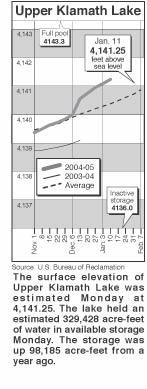
Clear Lake - Clear Lake's surface elevation was
estimated Tuesday at 4,522.64 feet above sea level,
with storage at 67,810 acre-feet, down 3,550
acre-feet from a year ago. River flow Link River 2005 2004 Jan. 6 626 858 Jan. 8 668 1,188 Jan. 10 666 495 Jan. 5 483 713 Jan. 7 569 1,017 Jan. 9 574 994 Klamath River at Iron
Gate Dam Jan. 6 1,037 1,454 Jan. 8 1,037 1,326 Jan. 10 1,037 1,312 Jan. 5 860 979 Jan. 7 1,746 2,217 Jan. 9 1,712 1,154 Williamson River Jan. 12 567 850 Snow report
|
Home
Page Updated: Thursday May 07, 2009 06:14 AM Pacific
Copyright © klamathbasincrisis.org, 2004, All Rights Reserved