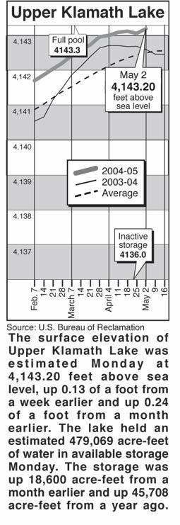
 |
Home
http://www.heraldandnews.com/articles/2005/05/04/news/water/water.txt
Lakes, rivers, snow
|
Clear Lake - Clear Lake's surface elevation was
estimated Monday at 4,523.13 feet above sea level, with storage at 75,440
acre-feet, down 53,820 acre-feet from a year ago.
Gerber Reservoir - The surface elevation of Gerber Reservoir was estimated
Monday at 4,814.1 feet above sea level, with storage at 26,470 acre-feet, down
22,140 acre-feet from a year ago.
River flow
Following are daily averages of the volume of water flowing at key points in the
Klamath Basin, measured in cubic feet per second:
Link River 2005 2004
April 26 1,090 1,340
April 27 992 1,247
April 28 567 1,567
April 29 592 1,327
April 30 725 1,355
May 1 577 1,332
May 2 548 1,456
A Canal
April 26 405 665
April 27 415 690
April 28 397 730
April 29 378 780
April 30 378 780
May 1 358 810
May 2 340 825
Klamath River at Keno Dam
April 26 1,200 1,097
April 27 1,230 1,082
April 28 1,040 1,081
April 29 881 1,103
April 30 813 1,102
May 1 805 1,102
May 2 803 1,226
Klamath River at Iron Gate Dam
April 26 1,460 1,663
April 27 1,450 1,663
April 28 1,610 1,663
April 29 1,760 1,655
April 30 1,610 1,655
May 1 1,470 1,600
May 2 1,550 1,600
Net inflow to Upper Klamath Lake
April 26 1,104 2,005
April 27 1,798 1,547
April 28 3,308 1,517
April 29 970 1,717
April 30 712 1,745
May 1 2,498 1,362
May 2 2,061 1,501
Williamson River
below Sprague R. 2005 Avg.
May 3 1,210 1,610
Source: U.S. Bureau of Reclamation, U.S. Geological Survey, Oregon Water
Resources Department.
Snow report
Following are today's estimates of the water equivalent measured in inches in
the snowpack at selected sites in Southern Oregon and Northern California.
Site Water Avg. Pct. of
content avg.
Adin Mountain .4 6.4 6
Billie Creek Divide 3.1 9.4 33
Cedar Pass 15.1 13.6 111
Chemult Alternate .1 .6 17
Cold Springs Camp 1.9 20.4 9
Dismal Swamp 28.9 24.0 120
Fourmile Lake 9.1 22.5 40
Sevenmile Marsh 12.6 21.7 58
Strawberry .2 .7 29
Taylor Butte 1.9 .1 190
Klamath Basin pct. of avg. 45
Goose Lake Basin pct. of avg. 99
Source: National Resource Conservation Service