Our Klamath Basin Water Crisis
Upholding rural Americans' rights to grow food,
own property, and caretake our wildlife and natural resources.
Our Klamath Basin
Water Crisis
Upholding rural Americans' rights to grow food,
own property, and caretake our wildlife and natural resources.
|
Weather, Floods,
Drought
A dry January foreshadows another tough year for the Klamath Basin, News10 1/24/22. "Gene Souza, Klamath Irrigation District Manager, says they’re anticipating an April water delivery to its users at the latest. He says with how low the reservoirs are right now, he’d need to pull water from the lake starting in February and that request has already been denied by the Bureau of Reclamation (BOR)...“The water that we take out to grow crops to sustain our families and communities, that water comes down here [Tule Lake] and benefits birds, fish, and other wildlife, bald eagle, wolves, coyotes..." Souza’s biggest frustration is that the water they use for their irrigation district all ends up back in the Klamath River anyways. He says whatever water runs off of farms and ranches and through the county all runs into the wildlife refuges, at which point excess water is pumped out to the river..."
Little to No water for Klamath
Project Farms in
2021,
Klamath Water Users Association 4/8/21 Water for irrigators: KWUA announces Project delivery, H&N 4/11/19. "Bureau of Reclamation’s Klamath Basin Area Office will deliver at least 322,000 acre feet of water — or a 92% allocation — rather than a full 350,000 from Upper Klamath Lake to the Klamath Project this summer and fall...Longtime legal counsel for KWUA Paul Simmons...was selected as executive director of the association..." KBC NOTE: an irrigator contacted and told us: "It is really less than honest to say the Project is getting 92% of their deliveries this year. If you go back to their original allotment, this year they are only actually getting around 69. All of our water, both upper and lower basin, continues to be "re-allocated."
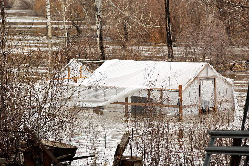
Sprague River rising to 8.4 feet, on flood watch, H&N 4/10/19.
Promising water outlook, but no promises, H&N 3/24/19. "The snowpack sits at 121 percent of median and Jeff Nettleton, manager of the Klamath Basin Area Office, projects a 325,000 acre feet or 93 percent of a normal water delivery for irrigators...'It is hard to see because you get 121 percent of average (snowpack), you would expect a full supply,” Johnson said. “Under the old ‘bi-op,’ you would have that. They’re just constantly chipping away at the allocation, and that’s what’s scary. The only thing it has going for it is a definitive allocation April 1 and, in theory, you can use it whenever you want to after April 1.' "
Klamath water year looks promising, H&N 3/21/19.
Bureau of Reclamation PUBLIC MEETING March 22, Friday,
1-3 at Klamath County Fairgrounds on 2019 water year.
(One whole day notice.)
Record February snowfall reduces drought concerns, H&N 3/12/19.
(Klamath) Commissioners predict ‘devastating’ summer for water users, H&N 2/1/18
Flows from Upper Klamath increase amid flood mitigation, Sprague River remains high, H&N, posted to KBC 3/23/17. "... the local snowpack is 113 percent of normal...No evacuations have yet been ordered as high waters along the Sprague River flow downstream, posing minor flood threats to properties in the Chiloquin and Sprague River areas."
Flooding possible along Sprague River, H&N 3/22/17
Klamath leaves five-year drought designation behind, H&N 10/26/16.
(Klamath) Basin water year looking dire, H&N
4/2/15. "As
of Wednesday, Upper Klamath Lake was 94 percent
full...Although
the Basin has received above normal
precipitation this winter, and much of the
region will experience showers in the next week,
the U.S. Drought Monitor categorizes the Basin
as being in 'extreme drought.'
" Drought declared in Klamath, H&N 4/7/15
Basin snowpack at 37 percent of normal;
No predictions for irrigation season,
H&N 1/13/15
Ongoing California drought wreaks significant economic damage. Crop, job losses take heavy toll on state, H&N 7/16/14.
Klamath Project irrigation: Basin water outlook grim, Snowpack called ‘worst in the state,’ H&N 5/1/14
Water Forecast Improves; projections not
enough to relieve Basin irrigators yet,
H&N 3/5/14. "...reserves
in Upper Klamath Lake have increased 10,000 acre-feet in the last month."
Snowpack is meager. Drought
brings dismal measurements, but all hope is not yet lost, H&N 12/31/13 Snowpack is concerning irrigators, H&N 2/7/12
FEMA: Yreka disaster center to close Saturday 3/3/06 "The center at 1712 Fairlane Rd. is staffed by federal, state and local officials and by volunteer agencies to provide information and answer questions for Siskiyou County residents who registered for disaster assistance for damage suffered in the December-January flooding."
Snow levels at 143 percent, Pioneer Press, posted to KBC 2/19/06. (Although there were floods on the Klamath this year, 143% snow, extremely above average precipitation, the Dept of Interior mandatory water bank demands 100,000 acre feet, or 1/4 of our stored irrigation water this year from Klamath farmers. HERE for waterbank page. KBC) According to the NRCS, Natural Resources Conservation Service, the Klamath Basin snowpack in 158 percent of normal. Flood reports on the Klamath: January 2 flood reports from Klamath, Redding, Eureka and Northern Ca.
USGS Real-Time Water Data for USGS 11502500 WILLIAMSON
RIVER BLW SPRAGUE RIVER NR CHILOQUIN,OR
Swamped,
Times Standard, posted to KBC 1/1/06
County under ‘state of
emergency', Siskiyou Daily News, posted to KBC 1/1/06 Flood threat rises in county, H&N 12/29/05."In the winter of 1996-97 a similar string of weather - snow, snow, more snow and then rain - caused the first severe flooding on both rivers since 1964. The flooding was the worst during the first week of January." {BEWARE OF FISHKILLS!! In the highest water years, like 1996 floods, there were the worst fishkills, and low-water years there were no fish kills, according to Klamath Irrigator and sports-fisherman John Crawford. KBC}
|
Home
Page Updated: Monday May 02, 2022 04:17 PM Pacific
Copyright © klamathbasincrisis.org, 2005, All Rights Reserved